


|
||

|

|
|

|
This is a great Thomas Bradford map of Eurasia and Northern Africa, showing the world as supposedly known by the citizens of the Roman Empire. Based heavily on Ptolemaic geography, it shows Europe in full, Africa north of "Ethiopia Interior," and southern Asia as far as northern Sumatra. Later interpretations of Ptolemy's works were subject to intense debate and reinterpretation, and this is shown on certain areas of the map. For example, Sri Lanka is given two possible names, Taprobana or Salice.
Detail is great on this map, with many given both classical and modern names. This is a fabulous map for comparing the changing nature of cartography over time, as this is a 19th-century reinterpretation of a 2nd-century work.
This work appeared in Bradford's atlas, which was a departure from other atlases of the period. Along with HS Tanner, Bradford produced an elegant, well engraved large format atlas on high-quality paper. The 1830s were a fascinating transitional period in both US geopolitics and in domestic cartographic publishing. Bradford's work is without question an important part of this era. His maps were engraved by GW Boynton or S. Stiles, Sherman and Smith.
Thomas Gamaliel Bradford (1802-1887) was an American geographic publisher. He hailed from Bradford, Massachusetts and began his publishing career by working for the America Encyclopedia. Then, he edited and republished the Atlas Designed to Illustrate the Abridgement of Universal Geography, Modern & Ancient, which had originally been offered in French by Adrian Balbi. In 1835, he published another atlas, A Comprehensive Atlas: Geographical, Historical & Commercial, and, in 1838, An Illustrated Atlas Geographical, Statistical and Historical of the United States and Adjacent Countries. His interests were primarily in educational publishing and he was one of the first mapmakers to show Texas as an independent country.
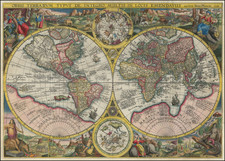
![Nova Totius Terrarum Orbis Geographica Ac Hydrographica Tabula. A Pet. Kaerio [First State -- With Handwritten Account of Sir Francis Drake's Voyage on the verso]](https://storage.googleapis.com/raremaps/img/small/81200.jpg)
![[The centre of this Slider is to be placed by a Thread or Pin over the centre of the respective Planisphere for any Operation]](https://storage.googleapis.com/raremaps/img/small/65557.jpg)
![[ World in Two Hemispheres on Polar Projections ]](https://storage.googleapis.com/raremaps/img/small/99920.jpg)
![[Pictorial World Map Gameboard]](https://storage.googleapis.com/raremaps/img/small/88775.jpg)