


|
||

|

|
|

|
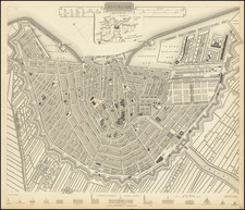
This is a vintage highly detailed town plan of Amsterdam, with abundant depictions of important buildings in the city. The map is oriented with the top to the northeast, which brings out the symmetry of the canaled city. This is one of the best available town plans of Amsterdam published in a commercial 19th-century atlas.
The map shows numerous roads, ports, canals, important buildings, parks, ramparts, and more. After the conclusion of the Napoleonic Wars, the long decline of Amsterdam began to reverse. Amsterdam was an important, though minor, center of trade for the remainder of the century, and would see unrest with the rise of socialism in the decades following the publication of these maps.
An inset map depicts the surroundings of Amsterdam, with Dangerdam, Zaandam, and Ouderkerk all shown. As of yet, only Zaandam has been conurbated, and is now a happening neighborhood, while Dangerdam is a small village and Ouderkerk is a commuter town. Fourteen important buildings of the city are shown along the bottom of the map, some of which still stand. Many churches are shown, including the Westerkerk, Noorderker, and the Lutheran Chuch. A "Zuyder Kerc," is named, but it is unclear what has happened to this church.
![[Holland] Holad](https://storage.googleapis.com/raremaps/img/small/78197.jpg)