


|
||

|

|
|

|
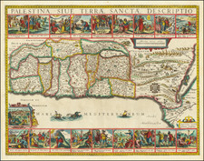
Finely colored and highly decorative map of the Holy Land, embellished with 18 decorative vignettes showing scenes of Moses from Exodus and a view of Jerusalem.
Based upon Van Andrichom, the map is oriented to the East, divided into the tribes on both sides of the Jordan, showing the shoreline from Sidon to Alexandria.
Jan Janssonius (also known as Johann or Jan Jansson or Janszoon) (1588-1664) was a renowned geographer and publisher of the seventeenth century, when the Dutch dominated map publishing in Europe. Born in Arnhem, Jan was first exposed to the trade via his father, who was also a bookseller and publisher. In 1612, Jan married the daughter of Jodocus Hondius, who was also a prominent mapmaker and seller. Jonssonius’ first maps date from 1616.
In the 1630s, Janssonius worked with his brother-in-law, Henricus Hondius. Their most successful venture was to reissue the Mercator-Hondius atlas. Jodocus Hondius had acquired the plates to the Mercator atlas, first published in 1595, and added 36 additional maps. After Hondius died in 1612, Henricus took over publication; Janssonius joined the venture in 1633. Eventually, the atlas was renamed the Atlas Novus and then the Atlas Major, by which time it had expanded to eleven volumes. Janssonius is also well known for his volume of English county maps, published in 1646.
Janssonius died in Amsterdam in 1664. His son-in-law, Johannes van Waesbergen, took over his business. Eventually, many of Janssonius’ plates were sold to Gerard Valck and Pieter Schenk, who added their names and continued to reissue the maps.
![[Cyprus, Holy Land, Syria, Arabia] Tabula Asiae IIII (with) Tabula Asiae III on Verso [Armenia, Georgia etc.]](https://storage.googleapis.com/raremaps/img/small/88877.jpg)
![[ Descendants of Noah ] Table historique du second age du monde tiree de la Genese...](https://storage.googleapis.com/raremaps/img/small/82009.jpg)
![(Israel) Tabula Moderna Terre Sancte [Modern Map of the Holy Land]](https://storage.googleapis.com/raremaps/img/small/101884.jpg)