|
||

|

|
|

|
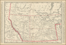
Nice example of this excellent map of Canada and the northern half of the United States, illustrating the routes of the Canadian Pacific Railway; The Minneapolis, St. Paul & Sault Ste. Marie Railway and The Duluth, South Shore & Atlantic Railway.
This map is of great importance in showing the progress of the various lines illustrated on the map, as it was updated on an annual basis from the late 19th Century to at least the late 1920s, providing a fantastic annual snapshot of the growth of these lines and the expansion of commerce in Western Canada and North Dakota.
While the map appears periodically on the market, it is deceptively rare, as there are probably at least 20-30 editions of the map in all, each showing the progression of the lines illustrated. Moreover, this is one of the early "enlarged" editions. In the early years, the maps was about 1/2 the size of this edition of the map, which bears the copyright of 1911.
The series of maps issued by these lines represents the only comprehensive graphic depiction of their expansion over this 35+ year period.
![Comparative Size of Lakes and Islands [Great Lakes, Cuba, Formosa, Ireland, Sicily, Cyprus, Vancouver, Sandwich Islands, Puerto Rico, Corsica, Sardinia, Balearics, Malta, etc]](https://storage.googleapis.com/raremaps/img/small/100135.jpg)