![[Amsterdam] Amstelredamum, Nobile Inferioris Germaniae Oppidum By Georg Braun & Frans Hogenberg](https://storage.googleapis.com/raremaps/img/small/96920.jpg)


|
||

|

|
|

|
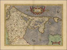
This is a finely colored example of Braun & Hogenberg's first view of Amsterdam, from Part I of their Civitates Orbis Terrarum, first published in Cologne in 1572.
Braun & Hogenberg's view is based upon a plan of Amsterdam by Cornelis Antoniszoon (1544), showing Amsterdam with its medieval walls and formal defensive systems. The view illustrates the unique Dutch form of urban planning. Here, the Amstel River is dammed near its mouth and its flow controlled by channels to the sea. An outer harbor is created from the downstream portion and an inner harbor is made from the upstream portion. The dam, located at the center, also provided the central plaza for public buildings. Numerous ships and fishing boats fill the harbors, attesting to the increased trade and commerce that Amsterdam was beginning to experience when this plan was published.
Cornelis Anthoniszoon (1505 to 1553) was a grandchild of Jacob Cornelisz van Oostsanen, who probably taught him to paint, and a cousin of Dirck Jacobsz. In 1538, Anthoinszoon painted the first complete map of Amsterdam as a commission from the city fathers to present as a gift to Charles V. Anthoniszoon. He is best known for his woodcuts, especially his view of Amsterdam, from 1544. This was printed in 12 blocks of wood and was re-issued until well into the 17th century.
The cartouche text translates as follows:
Amsterdam is a well-known city in Lower Germany that has arisen in recent times to accommodate merchants and is inhabited by people engaged in trade. It is almost impossible to think of a commercial activity that is not practiced here. Hence profit-seeking businessmen are drawn to this city from the most far-away lands and transship various goods, first and foremost grain, to Brabant and other parts of the world. Vast riches result from trade of this kind.
Braun's commentary on the verso translates as follows:
Holland is the a very fertile part of Lower Germany. It is crossed by many waterways, which are full of fish, she is also abundant in good quality pastures, and let us not deny that there is nowhere else in the world which, in so little space contains so many cities... Amongst these, Amsterdam is the noblest ... About twice a year many ships arrive here from all over Europe, some 200 or 300 principally from Flanders and also from elsewhere in the Low Countries, France, England, Spain, Portugal, Germany, Poland, Lithuania, Norway, Sweden and the other countries of the North.
Civitates Orbis Terrarum: The Greatest City Book
Georg Braun and Frans Hogenberg began the process of creating a comprehensive atlas of the cities of the world in 1572. Their book, Civitates Orbis Terrarum, was originally intended as a companion to Abraham Ortelius's Theatrum Orbis Terrarum, the first true atlas.
The great atlas was edited by Georg Braun, with Franz Hogenberg engraving many of the views. When the project was finished, the series would contain over 546 views (sometimes with multiple views on a single plate).
Civitates Orbis Terrarum includes the work of over 100 artists and topographers, perhaps most notable among them was the superlative talent of Joris Hoefnagel (1542-1600). He provided original drawings of Spanish and Italian towns, as well as reworking and improving the town drawings of other artists. After Joris's death, his son Jakob continued the project.
The Civitates provides an incredibly comprehensive view of urban life in the late 16th century. Many of the views in these volumes are the earliest of their respective towns -- either absolutely, or they are predated only by impossible rarities, as in the case of London. Cities portrayed range from the great capitals of Europe, Asia, Africa, and the Americas to small Swiss hamlets and other tiny villages. As such, this singular and indispensable source for understanding the early modern world.
The work was published in six volumes, each of which contained approximately sixty plates. The subject matter of each plate varied widely, it could provide a single view of a city, two views of the same city, or views of up to nine different cities. The range of designs is extensive, and it is interesting to compare the variety between views of the same city by two different authors.
Georg Braun (1541-1622) was born and died in Cologne. His primary vocation was as Catholic cleric; he spent thirty-seven years as canon and dean at the church St. Maria ad Gradus, in Cologne. Braun was the chief editor of the Civitates orbis terrarum, the greatest book of town views ever published. His job entailed hiring artists, acquiring source material for the maps and views, and writing the text. In this role, he was assisted by Abraham Ortelius. Braun lived into his 80s, and he was the only member of the original team to witness the publication of the sixth volume in 1617.
Frans Hogenberg (ca. 1540-ca. 1590) was a Flemish and German engraver and mapmaker who also painted. He was born in Mechelen, south of Antwerp, the son of wood engraver and etcher Nicolas Hogenberg. Together with his father, brother (Remigius), uncle, and cousins, Frans was one member of a prominent artistic family in the Netherlands.
During the 1550s, Frans worked in Antwerp with the famous mapmaker Abraham Ortelius. There, he engraved the maps for Ortelius’ groundbreaking first atlas, published in Antwerp in 1570, along with Johannes van Deotecum and Ambrosius and Ferdinand Arsenius. It is suspected he engraved the title page as well. Later, Ortelius supported Hogenberg with information for a different project, the Civitates orbis terrarium (edited by Georg Braun, engraved by Hogenberg, published in six volumes, Cologne, 1572-1617). Hogenberg engraved the majority of the work’s 546 prospects and views.
It is possible that Frans spent some time in England while fleeing from religious persecution, but he was living and working in Cologne by 1580. That is the city where he died around 1590. In addition to his maps, he is known for his historical allegories and portraits. His brother, Remigius, also went on to some fame as an engraver, and he died around the same time as his brother.