Sign In

- Or use -
Forgot Password Create Account
This item has been sold, but you can enter your email address to be notified if another example becomes available.
Description

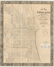
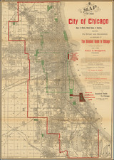
Rare Chicagoland Map Showing Extent of Great Fire.

This is a rare separately issued folding map by Rufus Blanchard, creator of some of the earliest maps of Chicago. This 1872 edition of the map shows the extent of the Great Chicago Fire which had burned the previous year, one of the earliest Chicago-printed maps to do so.

Two maps are included in the work showing Chicago and the greater Cook County as an already important metropolis, less than three and a half decades after the city's incorporation. On the right is a detailed map of Chicago, which details many streets and parks with great accuracy and colors the city according to wards. The map extends to the belt of parks and green spaces now including Douglass, Humboldt, and Garfield Parks, showing these with alternate names shortly after they were designated. Other interesting features include the recently completed Lake Tunnel, which served to bring clean water into the city. The map of Cook and Dupage Counties is colored according to six-mile blocks and shows early roads and railroads.

The depiction of the extent of the Great Chicago Fire from a Chicago mapmaker whose offices may have been affected by the fire adds a fascinating historical significance to the map. The damage from the fire can be seen to extend to Lincoln Park in the north and the Third Ward in the south. The fire is mostly bounded to the east by the Chicago river, though it did briefly jump the river into the Ninth Ward.

The map was published in at least several editions between 1868 and 1877, including an edition where it served as a promotional piece for an advertising firm. Blanchard would evolve this map into later maps including his New Bicycle Map Showing Carriage RoadsMap of Six Counties around Chicago, and Blanchard's Map of Chicago and Environs.

Blanchard issued some of the earliest available maps of Chicago and was one of the earliest printers to relocate to the Windy City. His offices were located at 132 Clark Street, which appears to be the present-day location of Chicago's town hall and almost certainly would have burned down.

The Great Chicago Fire

The Great Chicago Fire was a conflagration that burned in the American city of Chicago on October 8–10, 1871. The fire killed approximately 300 people, destroyed roughly 3.3 square miles (9 km2) of the city, and left more than 100,000 residents homeless.

Condition Description
Fold toning.
Rufus Blanchard Biography

Rufus Blanchard was a prominent American mapmaker, publisher, photographer, viewmaker, and bookseller, known for his contributions to Chicago during the latter half of the 19th century.  During his time in Chicago, he became on of its most important mapmakers and publishers both before and after the Great Fire, with a significant emphasis on pocket maps, railroad maps and similar guides and publications.

Blanchard was born in Lyndeborough, New Hampshire, and received his early education at Ipswich Academy. In 1835, Blanchard moved to New York City to live with his brother Calvin, who owned a bookstore at 78 Nassau Street. During this time, he witnessed two major events that shaped the city's history: the Great Fire of 1835 and the Wall Street Panic of 1836. Shortly after, Blanchard left the city, seeking solitude in the wilderness of Ohio, where he spent three years hunting and trapping.

By 1840, Blanchard returned to New York, taking a position with Harper Brothers, a well-established publishing house. His experience in the publishing industry encouraged him to open his own bookstore in Lowell, Massachusetts, in 1843. After a brief period of operation, Blanchard relocated to Cincinnati, Ohio, in 1846, where he partnered with his brother Edwin to open another business. Their success led to the expansion of operations to New Orleans, though this period was disrupted by the 1849 cholera epidemic. That same year, Blanchard returned to New York and entered a printing partnership with Charles Morse, the son of Samuel Morse, the inventor of the telegraph. He also collaborated with the prominent map publishers J. H. Colton.

By 1853, Blanchard had moved to Chicago, where he established himself as a printer and publisher. Recognizing the growing demand for railroad maps, he relocated his business to 52 LaSalle Street in 1854, where he began producing detailed maps for the rapidly expanding rail network. His contributions to the city included the publication of Chicago's first street guide in 1857, along with the opening of an office in Wheaton, Illinois, to extend his business reach.

In 1867, Blanchard's nephew, George Cram, joined him in the business, resulting in the formation of "Blanchard and Cram." The partnership proved successful until the Great Chicago Fire of 1871, which destroyed their Chicago office, along with a separate fire that consumed their Wheaton location. Despite these setbacks, Blanchard rebuilt his business, though Cram eventually left to establish his own firm, George F. Cram and Company. Another fire in 1885 devastated Blanchard's map stock, but he once again persevered, rebuilding his business.

Blanchard continued to be active in photography, writing, and publishing until his death at the age of 83. He was remembered for his resilience and dedication, described as a man who never "grew old in heart or brain," despite facing numerous challenges throughout his life.