


|
||

|

|
|

|
An Early Colorado Rarity
Extremely rare early map of Colorado, by Bonsall & Kellogg, published in Denver 4 years prior to Colorado statehood.
Fine early map of Colorado, including extremely early town plans for some of Colorado's most important Gold and Silver Mining towns.
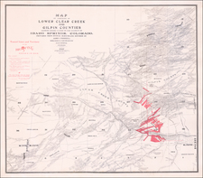
The main map is an unusually large treatment of the Front Range of the Colorado Rocky Mountains, including the progress of the tonwship surverys in Colorado, numerous towns, mountains, early roads, Railroads and other significant details, mapped at a much larger scale than virtually any other map of Colorado from the period. Many early post offies are located, as are mining regions and a number of mills.
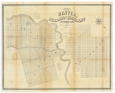
The work includes a fine map of all of Colorado, dated 1872, along with a larger map of Central Colorado, extending along the front range of the Rocky Mountains, and city plans of:
- Denver
- Central City
- George Town
- Boulder (1 year after its incorporation in 1871)
- Idaho
- Golden (1 year after its incorporation)
- Greeley
- Pueblo
- Colorado City
Rarity
The map is extremely rare. We find no record of any examples offered at auction or in dealer catalogs going back many decades.
We locate examples at Yale, British Library, and Museum of New Mexico Library.
The earliest recorded map of Colorado by Bonsall & Kellogg is a Philadelphia imprinted, dated 1871. The Denver Public Library also holds a manuscript map of a march, under command of Lieut. S.M. Bonsall, from Old Fort Lyon to Cheyenne Wells, Colorado Territory and back, June, 1868.
![The Mines of Colorado [with:] Map of Colorado Territory to accompany Hollisters](https://storage.googleapis.com/raremaps/img/small/100860.jpg)
![[ Colorado ]](https://storage.googleapis.com/raremaps/img/small/99487.jpg)

![Economical Features of S.W. Colorado, San Juan Mining Region [Atlas Sheet No. 61 (C)]](https://storage.googleapis.com/raremaps/img/small/88754.jpg)