
This item has been sold, but you can enter your email address to be notified if another example becomes available.


|
||

|

|
|

|
Stock# 6859
Description
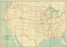
Outline color example of Purcell's Map of the Northern and Mid-Atlantic States. The map is most notable for the many land grants shown Western Territory, which then included Ohio, Tennessee and the Old Northwest Territory. The grants including Illinois Company, Army Lands, Wagbash Company, New Jersey Company, Ohio Company, and the 7 Ranges, along with the Donation Lands fro mthe Commonwealth of Virginia and General Clark's Grant 1500 acres. Many settlements are noted in the West, along with early forts Miami, Pitt, Venango, Chartres) and other interesting features. St. Louis appears on the map, as does Louisiville, St. Genevieve, New Madrid, St. Philips, Cahokir, and the Kaskaskais Village. A nice post-revolutionary war map of the region.
![[The Russian Question] Die Russische Frage. Ein Schauspiel von K. Simonow](https://storage.googleapis.com/raremaps/img/small/83978.jpg)
![(Extremely Rare American View Book) Les Ports de l'Amerique [8 engraved prints of American Cities: Philadelphia, Boston, Savannah, Fredericksburg, Charlestown, Chesapeake Bay, Quebec, and Port Royal] Graveé d'apres le Tableau de Vernet.](https://storage.googleapis.com/raremaps/img/small/95381.jpg)