


|
||

|

|
|

|
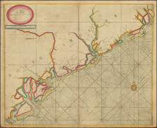
Scarce Revolutionary War edition of Thornton's map of the Coast of South Carolina from the English Pilot, Fourth Book. The map provides soundings and shows the settlements along the coast. It was originally drawn from Mathews manuscript map of 1685, with substantial additions. Extensive place names, rhumb lines, soundings, compass Rose, etc. A good example of the 18th Century Sea Chart of the Carolina Coast. AMPG shows that the map has not been offered in a dealer catalogue since 1987.
John Thornton was a respected and prominent chartmaker in London in the latter part of the seventeenth century. He was one of the final members of the Thames School of chartmakers and served as the hydrographer to the Hudson's Bay Company and the East India Company. He produced a large variety of printed charts, maps, and atlases in his career, but he was also a renowned manuscript chart maker. Born in London in 1641, he was apprenticed in the Drapers Company to a chartmaker, John Burston. After being made free of the company (1665), he was part of the combine that took over John Seller’ English Pilot in 1677. Thornton was trusted by the naval and navigational establishment of the day; one of his clients was Samuel Pepys, naval administrator and diarist. Thornton died in 1708, leaving his stock to his son, Samuel, who carried on the business.
Samuel, born in ca. 1665, also had apprenticed in the Drapers Company and was made free a year after his father’s death. He continued the business until 1715, when he died. His stock then passed to Richard Mount and Thomas Page.
![[ Middle British Colonies Map ] Pensilvania Maryland and Virginia](https://storage.googleapis.com/raremaps/img/small/98228.jpg)
![Carte Particuliere de Virginie, Maryland, Pennsilvanie, La Nouvelle Jarsey. Orient et Occidentale [Heighten in Gold!]](https://storage.googleapis.com/raremaps/img/small/61392mp2.jpg)

![A Topographical Description of Such Parts of North America as are Contained in the (Annexed) Map of Middle British Colonies, &c. in North America [with map:] A Map of the Middle British Colonies in North America. First published by Mr. Lewis Evans ... in 1755; and since Corrected and Improved, as also extended with the addition of New England, and bordering parts of Canada; from actual surveys ... by T. Pownall](https://storage.googleapis.com/raremaps/img/small/100077.jpg)