


|
||

|

|
|

|
Lands of an Anti-Federalist Member of the Constitutional Convention
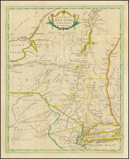
Finely executed 2-sheet manuscript cadastral map of Adgate’s Patent in today's Oneida County, New York.
The present map is a remarkable document, seemingly recording every land transfer between from 1794 until 1864, with transfers recorded in multiple hands in black pen, red pen and pencil. The map also provides a meticulous accounting the roads and rivers in the region.
The map is centered on Boonville, and extends to the area near Forrestport on the Black River at the bottom right, and the area around Popple Pond State Forest at the top right. The area shown comprises most of the northeastern "triangle of Oneida County, including Boonvville, Forestport, Ava and the Jackson Hill State Forest.
Each parcel has a land owner written in, many with subsequent purchasers as well, with dates added as late as 1864.
Wright was the senior engineer of the Erie Canal, but this would have represented some of his earliest work surveying in Oneida and Oswego Counties (See DAB, v.X, p.543).
Adgate's Patent
Matthew Adgate (1737–1818) was born in Norwich, Connecticut, but eventually settled in the part of Albany County, New York, which later became Columbia County.
Adgate became politically prominent during the American Revolution and represented Albany County in the convention that drafted New York’s state constitution in 1777. Elected one of Columbia County’s delegates to the convention called to ratify the Federal Constitution, he assumed an active role in the antifederalist coalition and voted against ratification.
Adgate served several terms in the state assembly and as a judge of the court of common pleas for Columbia County. He later moved to Clinton County, where in 1818 he published A Digest, or, Plain Facts Stated: In Which the Gospel and Law Are Compared in Some of Their Most Important Parts . . .
In 1761, Adgate purchased a parcel of land estimated to be 45,000 acres., for two shillings six pence per acre, which became known as Adgate's Western Tract, and lies next to Macomb's Purchase. A patent was issued January 20, 1798.
Another tract called Adgate's Eastern Tract, of 40,000 acres, was owned by Adgate, lying partly in Oneida county and partly in Herkimer county.
In 1794, Benjamin Wright surveyed the western tract into lots west of Black River.
Rarity
This map is very similar to, but not identical to several maps in the Holland Company archives at SUNY-Fredonia. (www.wnylegacy.org).
![[Niagara Falls] Cataracte de Niagara](https://storage.googleapis.com/raremaps/img/small/96890.jpg)
![[Pennsylvania, New Jersey, New York ] Speciel Land Charte von Pensilvanien, Neu Jersey, Neu York und von denen drey Land-schafften an dem Delaware Fl. In America in Englischer Spr. gedruckt A. 1749 In Europa duffgelegt in Teutsch Spr. zu Francfurt am M. A. 1750.](https://storage.googleapis.com/raremaps/img/small/51958.jpg)
![[ New England / Northeast / Canada ] Tierra Nueva](https://storage.googleapis.com/raremaps/img/small/86737.jpg)