


|
||

|

|
|

|
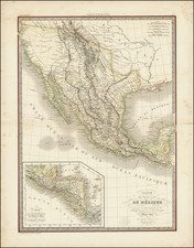
First Edition of the First Printed Map of the Republic of Texas
First edition of Bradford's map of the Republic of Texas, the first printed map of the Republic.
The map identifies the early Land Grants in Texas, as well as important early roads. Grants named include: "Stephen F. Austins Grant," "Burnets Grant," "Dewitts Grant," "Zavalias Grant," etc. Other areas labeled include "Comanches Indians" and "Austins Colony."
The first state of the atlas includes the 2 page text sheet, describing the Republic of Texas. Later editions include only 1 page of text. Other early features include "Mustang Wild Horse Desert" in south Texas; Nueces River as southwestern boundary with Mexico and land grants shown, instead of counties
An essential map for Texas collectors, the first edition of the first reasonably obtainable separate map of the Republic of Texas.
Thomas Gamaliel Bradford (1802-1887) was an American geographic publisher. He hailed from Bradford, Massachusetts and began his publishing career by working for the America Encyclopedia. Then, he edited and republished the Atlas Designed to Illustrate the Abridgement of Universal Geography, Modern & Ancient, which had originally been offered in French by Adrian Balbi. In 1835, he published another atlas, A Comprehensive Atlas: Geographical, Historical & Commercial, and, in 1838, An Illustrated Atlas Geographical, Statistical and Historical of the United States and Adjacent Countries. His interests were primarily in educational publishing and he was one of the first mapmakers to show Texas as an independent country.
![(Texas Mexico Borderlands) [Map of the Rio Grande, Texas - Mexico border, from the Big Bend to the town of Mier] Copiado del Mapa de S. Mc. L. Staples, 1828... Dibujado y extractado de los documentos y datos dichos, por F. L. Mier - Monterey, Diciembre de 1873.](https://storage.googleapis.com/raremaps/img/small/91667.jpg)
![The Rise, Progress and Prospects of the Republic of Texas [including:] Map of Texas, compiled from Surveys recorded in the Land Office of Texas, and other Official Surveys, By John Arrowsmith. [and:] A Map of the Republic of Texas and the Adjacent Territories, Indicating the Grants of Land Conceded under the Empresario System of Mexico.](https://storage.googleapis.com/raremaps/img/small/94046.jpg)