|
||

|

|
|

|
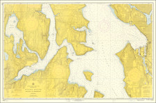
This is a vintage survey map of Snohomish county, stretching in scope from the shores of Puget Sound to the Cascades. Detail is extensive, with rivers, roads, railway lines, lakes, mountains, and more all demarcated. Towns in the region, still small, include Everett, Edmonds, Snohomish, Arlington, Stanwood, and Marysville. Mount Lake Terrace is marked as Seattle Heights. Islands visible in Puget Sound include Whidbey Island and Canamo.
Early twentieth-century Snohomish has one infamous claim to fame, the Everett massacre. By 1910, Everett had won the nickname "milltown" as it had become the center of the Washington timber industry. Everett had particularly flourished with the rebuilding of San Francisco following the 1906 earthquake. With the advent of labor unions, conflict rose between local organizers and the local sheriff. The IWW sent delegates, but these activists were fired upon as they tried to enter the city, with at least twelve fatalities. Public opinion was strongly against the IWW, and the conflict remained little-acknowledged until the end of the century.
The map cover booklet contains a pen manuscript notation signed Deerson Jhou (?) Ken. Whether this is an individual, or a list of names, is uncertain.
![[ Whidby Island, Washington ] Penn Cove Park: your homesite on Whidby Island. . . [with five printed photos of Whidby Island streets including four aerial shots].](https://storage.googleapis.com/raremaps/img/small/98838.jpg)
![[San Francisco to British Columbia] Carta particolare dello stretto di Iezo fra l'America e I'Isola Iezo . . . D'America Carta XXXIII](https://storage.googleapis.com/raremaps/img/small/67788.jpg)