|
||

|

|
|

|
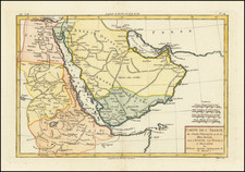
This is an antique map showing the East African coastline, extending from the mouth of the Red Sea to the Island of Zanzibar. The work was originally included in Karl Muller's Geographi Graeci minores, alongside many other maps of the region.
The map is highly detailed, showing many settlements, mountains, wadis, and more. The map is composed of four insets, with the largest focusing on the Somali coast. Most interestingly, Muller models one inset after a Greco-Roman periplus describing the western Indian Ocean. On this inset, Muller notes the travel times between adjacent ports, ostensibly following the notes in the Periplus.
Karl Muller's Geographi Graeci minores appears to be a partial attempt to collect the vast geographical knowledge of the Greeks. Herein he describes provides some new translations, describes the knowledge of the ancients, and compares his findings to modern geography. The work was published at a time when the studies of the ancient world were just starting to be done in a modern fashion.
Works such as Muller's are an often-underutilized source of knowledge regarding the antiquities. Fenet states that "The majority of the nautical voyages collated by Muller need modern and detailed commentary. Recent publications have started to use these types of sources more frequently." In all, this is work and map were an important early modern study on the subject.
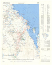
![[Jubail, Saudi Arabia]. Location of Archaelogical Sites - Jubail Area](https://storage.googleapis.com/raremaps/img/small/82295.jpg)