|
||

|

|
|

|
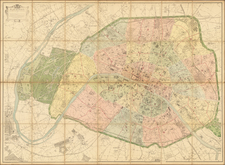
Striking, Detailed Plan of Eighteenth-Century Paris
Finely colored example of this plan of Paris, published by Jean Lattré. It shows the city in stunning detail as it was prior to the French Revolution and the nineteenth-century renovations of Haussmann.
The city plan focuses on the center of Paris, which hugs both banks of the Seine. Grand, tree-lined promenades are prominent, ringing the city and outlining the surrounding faubourgs, or suburbs. Many large building complexes are familiar to a modern visitor to Paris, including the Les Invalides, the Tuileries, Notre Dame, and the Louvre.
Each city block shows the extent of construction, with street names running along the avenues and alleys. Churches are marked with crosses, while a series of important buildings are colored red. These are explained in the legend in the lower left corner and include parish churches, colleges, hospitals, monasteries, convents, fraternal organizations, seminaries, and “edifices remarquables”, or remarkable buildings. A key running along the bottom edge of the plan explains the symbols for prominent buildings in the suburbs and surrounding villages.
Running along either side of the plan are two reference tables. They serve as an alphabetical index of businesses, buildings, and locations according to the grid system on the plan.
In the upper right corner is a particularly ornate cartouche. It is surrounded by laurels and the coat of arms of the faubourgs and towns. At top is a ship in full sail, with a sea monster and the instruments of war.
The cartouche explains that the plan is dedicated to the Provost of the Merchants Antoine-Louis Le Fèvre de Caumartin, holder of this title from 1778 to 1784. He was a noble from a prominent family and an official of the Ancien Régime. Prior to being named Provost of the Merchants of Paris, he was a member of the Grand Council and a provincial intendant. He survived the French Revolution and died in 1803. His family’s coat of arms, simple blue and white stripes, is at the bottom of the cartouche.
Paris in the eighteenth century
Paris was the intellectual center of Europe in the eighteenth century, and its second largest city. Based on parish records, 500,000 people lived there at the beginning of the century; by 1789, that number had grown to roughly 650,000. It was also a grand city, famous for its architecture. Many of the buildings included here were built in this century, while others underwent significant changes: for example, the museum in the royal place of the Louvre opened at this time.
When the century began, Paris and France were still under the reign of Louis XIV, the Sun King, who was responsible for the Palace of Versailles. While wary of Parisians, who had run him out the city twice in his youth, he sought to make Paris a city of monuments. He oversaw the construction of many Parisian landmarks, including Les Invalides and the Place de Vendôme. He rebuilt the Louvre and Tuileries into their now recognizable forms. He also began construction on the Church of Saint-Sulpice (finished in 1745), the Church of Saint-Roch (finished 1740), and others. Finally, Louis XIV ordered that the old city walls be pulled down and replaced by the boulevards seen here.
Louis XIV died in 1715 and was succeeded by his five-year old great-grandson, Louis XV, who ruled from 1715 to 1774. He also built important buildings that defined Paris. Most prominently, he ordered the construction of the École Militaire, near Les Invalides. He also began the Church of St. Genevieve, which became the Panthéon in the French Revolution. A new grand plaza was laid out in the King’s honor, just at the end of the Tuileries Gardens, the Place de Louis XV.
Rarity
Lattré released a series of plans of Paris in the late-eighteenth century. This example, with its distinctive cartouche, is among the rarest of those plans. OCLC locates only three institutional examples, all in European libraries. This is the first time we have offered this version of the plan in three decades of business.
Additionally, the inclusion of the indexes at the sides are not often seen in surviving examples. The index, and the fine coloring of this example, make it a particularly desirable item for those interested in eighteenth-century, pre-revolutionary France.
Jean Lattré (fl. 1743-1793) was a Parisian bookseller and engraver who published many maps, plans, globes, and atlases. He worked closely with other important French cartographers, including Janvier, Bonne, and Delamarche, as well as other European mapmakers, such as William Faden, Santini, and Zannoni. Lattré is also interesting due to his propensity to bring suits against those who copied his work; plagiarism was common practice in eighteenth-century cartography and mapmakers struggled to maintain proprietary maps and information.
![[ Saint-Denis ] Pourtraict de la Ville de Sainct Denis en France](https://storage.googleapis.com/raremaps/img/small/74991.jpg)

![[ Paris ] Plan Routier De La Ville et Faubourg De Paris 1772](https://storage.googleapis.com/raremaps/img/small/92313.jpg)