


|
||

|

|
|

|
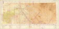
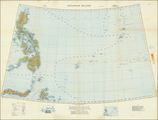
First edition of this important map of the Philippine Islands, published by the War Office of the British Ordnance Survey.
The present map would become the primary regional military planning map of the region for Great Britain for at least the next 4 decades and was revised a number of times thereafter.
A key at the bottom right identifies a list of source maps, published between 1910 and 1922 in Manila, New York, London, and Batavia, including a single entry for 6 British Admiralty Charts.
Published on a Conical Orthomorphic Projection, this map would be repeatedly updated and improved until at least the 1960s.
The War Office was a department of the British Government responsible for the administration of the British Army between the 17th century and 1964, when its functions were transferred to the Ministry of Defense. The name "War Office" is also given to the former home of the department, the War Office building located at the junction of Horse Guards Avenue and Whitehall in central London.