|
||

|

|
|

|
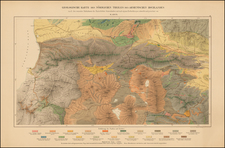
Fresno, California Imprint! -- Striking and Informative Brochure Map of Armenia Celebrating Armenian History and Culture
Fine map of Armenia SSR by a noted Armenian printer and scholar.
The central map shows Armenia’s borders as it existed under the USSR, while the document also features a series of inset maps and images that highlight Armenia’s heritage.
The map and the verso text are an advertisement for the author’s cultural and historical atlas of Armenia, Hay Adlas (Historical Atlas of Armenia, Fresno, CA: 1957). Babessian uses florid prose to describe his project, as well as intriguing visuals that share historical moments, geographical movements and areas of interest, as well as architectural achievements.
The central map carries a variety of information about the area. The tables in the upper right corner explain the comparative size of Armenia’s lakes and rivers, its size relative to Asia, its mineral resources, and types of terrain. In the lower left are tables explaining the size of Armenia’s diasporic population across five continents, the locations of that diasporic population, the comparative size of the population of old and new Armenia, the comparative size of Armenia and Belgium, and a regional inset map.
The images that surround this larger map are also instructive to the student of Armenia. The innermost ring are images of important buildings in Armenian culture, most of which are churches. From the top left corner, and continuing clockwise, these are: Gatoghige Church (Ani), Asdvadzazin (Ashdarag village), Khtsgonk Monastery (Shirag), Khoshavank (Ani), Echmiadzin, Tanahadits Monastery (Vayots Tsor, Siunik), Marmashen Church, Khoshavank (Ani), Surp Asdvadzadzin (Bjni), Church of the Savior (Ani), St. Garabed (Garni), Church of the Shepherd, St. Kayane (Echmiadzin), Sanahin Monastery, St. Hripsime (Echmiadzon), Arakelots Churches (Sevan Island), Kantasar Monastery, St. Gregory the Illuminator (Ani), St. Gregory (Ani), Mother Church (Ani), Surp Harutiun (Gizaris), Vorodna Monastery (Siunik), Echmiadzin Bell Tower, and Gatoghige (Gizaris).
A series of profiles feature prominent Armenians. From the central motif at top left, and continuing clockwise, these are: The Deathless Trinity of St. Mesrob, Nerses the Great, St. Sahag, King Vramshabuh (with biography), Vahan Manigonian, Ardashes I, Dikran the Great, Vartan Mamigonian, and King Artavazd II (with biography).
Five insets map are in the final ring of information. On the right, from top to bottom, these are a map of Cilician Armenia, Yerevan and its environs, and Garin (modern Erzurum). At left, there is a map of Lake Van and Kharpert (modern Elazig).
Finally, in the middle of the far-left column is a sunrise over a mountain with the date of May 28, 1918. This is the date of the first Armenian Independence Day. The mountain is Mount Ararat, with Echmiadzin to the right.
One of the figures shown on the front of the work is St. Mesrob Mashtots, most famous for inventing the Armenian Alphabet (there is some scholarly indication that a pre-Mashtots Armenian alphabet may have existed, from which he drew inspiration). The alphabet, with thirty-nine flowing letters, was created in the fourth century and has seen periods of widespread popularity abroad. The script, which appears on this map, was instrumental in leading to the formation of an Armenian national identity.
Hay Adlas (Historical Atlas of Armenia)
This document is an advertisement for Babessian’s larger project, Hay Adlas. This atlas was meant to teach the Armenian diaspora, especially Armenian children born abroad, Armenian history, culture, and geography.
Such a project was particularly necessary due to the history of Armenia in the twentieth century. After the Armenian genocide—which saw 1.5 million Armenians dead at the hands of the Ottoman Empire during WWI—many Armenians moved abroad to countries such as Lebanon, Syria, and the United States. Babessian feared the cultural assimilation and loss of Armenian identity amongst the children of these immigrants, hence his work on this atlas.
With such important motivation behind the project, it is unsurprising that Babessian employed colorful language, and imagery, to sell his book. He called the atlas the greatest work of Armenian printing since the advent of the practice in Venice in 1512. In the verso text, he includes the large dimensions (40.5”x 29.5”) and considerable weight (7.5 lbs.) of the book, as well as shared the type of paper on which it was printed (Kromekote). He further described his process:
Upon buying a printing press I began printing Hay Adlas page by page, whose publication took four years and cost 16,000 dollars for 800 copies, without counting my 13,000 hours of work. If counted as money, at a rate of $4 an hour, comes out to an amount worth $52,000, which added to the preceding sum comes out to 68,000 dollars.
This converts to nearly $600,000 dollars in today’s currency. Considering his significant input, Babessian was selling his atlas at a bargain price:
You will pay only $31.20 for this, but with this book your name will live on. Your payment is mere pennies compared to the many thousands spent by the author. The author spent those many thousands gladly, with his sole intent being to baptize your child an Armenian and return them to you.
The Library of Congress has an example of the atlas.
Armenia
Armenia is recognized as one of the oldest western cultures. The country credits its legendary founding to Hayk (source of the historical name of the country), who fought against the Babylonian God of War. There may be some truth in this legend due to the date coinciding with archeological evidence for the contemporaneous fall of the Akkadian Empire.
Two-and-a-half-millennia later, Armenia cemented its place as a center of western culture by being the first nation to adopt Christianity. Armenia saw both successful and turbulent times over the next millennia-and-a-half. The country declared its independence from the Ottomans on May 28, 1918 (prominently shown on the map), before being joined to the USSR in 1922. Once again having achieved independence in 1991, Armenia is now a democratic and deeply religious state.
Originally from Amasya, Turkey, Babessian was a survivor of the Armenian Genocide and an emigre first to Uruguay and then to the United States. Despite his frequently uprooted life, he authored many works, including the notable Hanrakidag (Encyclopedia) (1922). In 1960, he travelled to Lebanon to reprint this book on the press of the Armenian Catholicosate. He is also the author of Hay Adlas (Armenian Atlas), which he wrote and printed himself.
![[ Black & Caspian Sea Region ]. Tabula Asiae III [](https://storage.googleapis.com/raremaps/img/small/76322.jpg)
![[ Tibet / Nepal / Himalyas ] Carte von Tibet nach den neuesten Nachrichten entworfen 1790](https://storage.googleapis.com/raremaps/img/small/86165.jpg)
![(Russian Adventurism in China) Карта Средней Азии Составлена К. Веберомъ... 1871. [Map of Central Asia Compiled by K. Weber... 1871.]](https://storage.googleapis.com/raremaps/img/small/58597.jpg)
![[Peninsula of Qatar shown] Map of Persia, Arabia, Turkey in Asia, Afghanistan, Beloochistan](https://storage.googleapis.com/raremaps/img/small/100289.jpg)