|
||

|

|
|

|
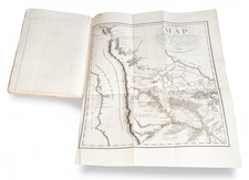
This is the second edition of Wilkes map from the United States Exploring Expedition, showing remarkable details throughout the region. This is the reduced version of Wilkes' of Oregon Territory, a map that made a major contribution to American cartography and was widely considered the most detailed map of the region north of the Sacramento River. The map includes an inset of the Columbia River from Walla Walla to Cape Disappointment.
Wilkes' map provided an early accurate depiction of Oregon Territory, a thinly settled part of the United States even in the 1840s. Wilkes supported the popular view that the northwest boundary of America should be 54 deg. 40' North, the famous "54-40 or Fight" controversy, championed by Senator Lewis Linn. This map was used to support his claim that was based on 'topographical' grounds and was instrumental in setting the scene for American interests in the territory, despite the fact that the map does not extend so far north, nor is there a clear geographical divide.
The map covers the region from Fraser's Fort and Fort St. James in British Columbia south to the upper Sacramento River, and from the Pacific coast to the Black Hills east of the Rocky Mountains. The map provides excellent detail of the region including dozens of forts, watershed, and other place names. A large inset map "Columbia River Reduced from a survey made by the U.S. ex. Ex. 1841" depicts the river from Ft. Walla Walla to its mouth, where one of Wilkes' ships, the Peacock, was lost on the infamous Columbia Bar. It includes details of missions, Indian villages, and the major mountains with north oriented to the left.
As noted by Wheat:
This map was in many respects the most detailed of this extensive area yet published, and for the main Oregon region and the Hudson's Bay Company territories to the north it was an accurate, really quite extraordinary, map . . . This map had much influence on the later maps of the area.
The map was quite popular and was used to illustrate several gold rush era overland guide books.
The U. S. Ex. Ex.
The US Exploring Expedition, shortened to the U. S. Ex. Ex., was a major expedition taking place from 1838 to 1842 centered on exploring the Pacific Ocean and the surrounding coasts. The expedition, sometimes popularized the Wilkes Expedition, after its second commanding officer Charles Wilkes, was a long time in the making. John Quincy Adams had already approved the mission as early as 1828, but repeated funding attempts were stalled. Shortly before the voyage happened, Commodore Jones resigned due to the vast amount of procrastination that had taken place.
The expedition was finally launched under the talented Charles Wilkes in August of 1838. The voyage set sail towards Madeira, before rounding Cape Horn. The Ex. Ex. traveled throughout the Pacific for three years, visiting many islands including Australia, New Zealand, and Hawaii, before voyaging to the Columbia River, which they reached in 1841. Extensive travels were taken throughout the island, and when the Peacock ran aground, the crew set up Peacockville. From there, surveys departed northwards and southwards, completing such tasks as an extensive survey of northern California. The crew ould depart in September and return to New York in 1842. Despite the success of the expedition, Wilkes would be court marshaled on his return due to his mistreatment of subordinates.
Charles Wilkes (1798-1877) was a skilled naval surveyor and the commander of the United States South Seas Exploration Expedition (U.S. Ex. Ex.), the largest scientific voyage ever mounted by the United States. Wilkes was born in New York City and began to sail in merchant vessels from 1815-1917.
Wilkes joined the United States Navy as a midshipman in 1818; by 1826, he had risen to the rank of lieutenant. Fascinated by hydrography, Wilkes studied triangulation and surveying with Ferdinand Hassler, the first superintendent of the United States Coast Survey. This expertise and initiative led him to be named Director of the Navy’s Depot of Charts and Instruments in 1833.
After being stalled by the Navy, U.S. Ex. Ex.—the U.S. response to the scientific voyages of Cook and La Perouse—was finally preparing to sail in the late 1830s. Wilkes was offered command, thanks to the heavy surveying focus on the voyage. He was given command of six vessels and nine scientists. However, the ships were not well supplied and the expedition was executed with some difficulty.
The ships left Norfolk in August 1838. They went in convoy to Tierra del Fuego, where they split and some explored in the South Seas and others in the South Atlantic. In late 1830, Wilkes surveyed portions of Antarctica that today are named for him (Wilkes Land). From spring 1840, the ships explored the mid- and North-Pacific. In June 1842, Wilkes returned to New York Harbor with only two of his six ships and a mountain of ethnographic, botanical, and natural historical specimens, as well as reams of observations, drawings, and charts.
Wilkes was met with a court martial; while he was acquitted of most charges, he was convicted of illegal punishment and reprimanded by the Secretary of the Navy. Despite this, he was promoted commander in 1843, captain in 1855, and commodore in 1862.
Wilkes spent much of his remaining career overseeing the publications of the expedition. The first official publication to appear was Wilkes’ rambling five-volume narrative of the voyage, accompanied by a folio atlas, in 1844. A further 19 volumes were prepared over the course of 30 years, each on a different scientific topic, although only 14 were ever distributed. Perhaps the most impressive legacies of the expedition were the almost 250 charts Wilkes prepared in two atlases (completed 1858, published 1861, but not distributed until after the Civil War). These formed the basis of the United States Hydrographic Office.
Wilkes served in the Union fleet in the Civil War. In 1864 he was before a court-martial again, this time for the publication of a private letter to the Secretary of the Navy. He was found guilty. He retired two years later, in 1866, and died in Washington D. C. in 1877.
![[Washington & Oregon] Amer. Sep. No. 38. Partie Des Etats-Unis](https://storage.googleapis.com/raremaps/img/small/93549.jpg)