


|
||

|

|
|

|
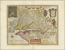
The First Dutch Map of Virginia
This is a fine example of Blaeu's map of Virginia and the Chesapeake region, based upon the most important map of Virginia published in the 17th century.
This is the second state of Hondius' rare separately issued map, first engraved by Jodocus Hondius in 1618 and purchased by Blaeu following Hondius' death in 1629. The map depicts the discoveries in the region detailed by John Smith in his seminal map of Virginia, first issued in 1612. Because of the commercial success of Blaeu's Atlases, it is Blaeu's map of Virginia which influenced two generations of European mapmakers regarding the English mapping and discoveries in the region. It remained the primary influence on other maps of the period and the standard map of the region until Augustine Hermanns' map of 1673.
In 1606, the London Company sent its first ship to Virginia and established the Jamestown settlement. The English settlers were, of course, accompanied by Captain John Smith. Between 1607 and 1609, Smith explored the major rivers which flowed west into the Chesapeake Bay, recording the names of the Native American villages and tribes he encountered. The limits of Smith's explorations are marked with a Maltese cross, which Blaeu incorporates on his map and can typically be seen at the upper part of each of the rivers depicted on Blaeu's map. Beyond the crosses, Smith relied on Native American accounts to delineate territories further upriver. Smith notes on his map that "To the crosses hath bin discoverd what beyond is by relation," they are here marked as "English lucubrations."
Upon Smith's return to England in 1609, he employed William Hole to engrave a map, which was first included in a small pamphlet by Joseph Barnes of Oxford in 1612. Jodocus Hondius engraved the first edition of this map in 1618, making it the second appearance of Smith's original manuscript to appear in print. Smith's original map would not appear again until 1624, when it was included along with Smith's map of New England in his landmark work, The Generall Historie of Virginia, New-England, and the Summer Isles, in 1624. The following year it was included in Purchas His Pilgrimes, by Samuel Purchas.
There is some question as to whether the original map is the work of Smith, who led most of the explorations, or the surveyor accompanying him, Nathaniel Powell. The original Smith map can be viewed here: /gallery/detail/23677.
The map is fabulously decorated. In the upper left, a Powhatan tribal scene can be found, apparently witnessed by Smith, is shown. Another Native American is shown in hunting clothing on the left of the map, armed with a large bow. Three key-style cartouches appear, along with the coat of arms of the United Kingdom, and a decorative compass rose.
An essential map for collectors of this region.
Willem Janszoon Blaeu (1571-1638) was a prominent Dutch geographer and publisher. Born the son of a herring merchant, Blaeu chose not fish but mathematics and astronomy for his focus. He studied with the famous Danish astronomer Tycho Brahe, with whom he honed his instrument and globe making skills. Blaeu set up shop in Amsterdam, where he sold instruments and globes, published maps, and edited the works of intellectuals like Descartes and Hugo Grotius. In 1635, he released his atlas, Theatrum Orbis Terrarum, sive, Atlas novus.
Willem died in 1638. He had two sons, Cornelis (1610-1648) and Joan (1596-1673). Joan trained as a lawyer, but joined his father’s business rather than practice. After his father’s death, the brothers took over their father’s shop and Joan took on his work as hydrographer to the Dutch East India Company. Later in life, Joan would modify and greatly expand his father’s Atlas novus, eventually releasing his masterpiece, the Atlas maior, between 1662 and 1672.


![[The First Maps Printed Color] Cartes en Couleur des Lieux Sujets aux tremblements de Terre Dans toutes les parties du Monde Selon le Sisteme de l’impulsion Solaire](https://storage.googleapis.com/raremaps/img/small/52293op.jpg)