|
||

|

|
|

|
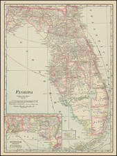
This is a street map of St. Petersburg, Florida, showing the city at the end of the 1960s. At that time, development stretched northwards to Pinellas Park and Seminole. The map is detailed, showing many roads, parks, golf courses, developments, and more. Insets show downtown St. Petersburg and the Fort de Soto area. An index lists hundreds of streets.
The verso shows an additional two maps. The first shows the upper part of the Pinellas peninsula as far north as Crystal Beach and Palm Harbor. Cities, towns, and other developments spotting the area can be found, including Clearwater, Oldsmar, Belleair, and Safety Harbor. Another map shows the greater Tampa Bay area, stretching from Tarpon Springs to East Tampa.
St. Petersburg has been a tourist hub since the early 1900s. The city saw a particular rise in population during the 1950s, as transport options increased. Several new bridges had just been built as of the making of this map, including the Sunshine Skyway which connects Mullet Key, site of Fort de Soto, to the mainland.