|
||

|

|
|

|
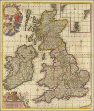
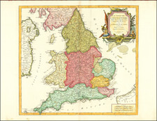
The First Map of England and Wales Published in England. The Cornerstone Map for all British Isles Collections.
Original hand-colored example of the first English printed map of England and Wales, by Christopher Saxton, "the father of English cartography".
Saxton's map was absolutely foundational, having significantly improved upon anything that came before it. Mercator, Speed, Blaeu, Jansson, and many other cartographers of the 16th and 17th centuries would rely on Saxton for their maps of England and Wales.
The map was the product of Saxton's survey of England, which he commenced in 1574. Despite the arduous and groundbreaking nature of the surveying work, the first plates were already being made in 1574 and the work was complete in 1578. Some have suggested that Saxton relied on John Rudd's earlier surveys to speed up the process.
The products of that survey, including the present map, originally appeared in Christopher Saxton's Atlas of the Counties of England and Wales (1579), the first English county atlas. That atlas was made possible through the sponsorship of Queen Elizabeth and William Cecil, Lord Burghley, Elizabeth's chief adviser. Thomas Seckford, who commissioned the survey from Saxton, is honored on this map with the inclusion of his coat of arms including his motto "Industria Naturam Ornat."
The map was engraved by Augustine Ryther, the most accomplished of the three English engravers used by Saxton. Ryther signed the plate under the scale of miles: "Augustinus Ryther Anglus Sculpsit Ano Dñi 1579".
The title cartouche is surmounted by the Coat of Arms of Queen Elizabeth I, and from it dangle fish and lobsters, one of the numerous allusions to England's reliance on the sea throughout the map. Sea monsters and sailing ships - not uncommon in maps of the time - are absolutely teeming in the waters around England and Wales. While Henry VIII had founded the Royal Navy, Queen Elizabeth made naval strength a central feature of her foreign policy, something that would be true of England from that point onward. Elizabeth's investment in the navy would pay off, nine years after the publication of this map, when the harried the Spanish Armada in the English Channel, foiling the Habsburg attempt to invade England.
In the upper-left corner, an index ("Index Omnium Comitatuum, notis et figuris suum cuique situm et ambitum designantiub") lists the Latin names of 52 counties in England and Wales. The numbers given in the index correspond to those on the map.
States
This is an example of the second state. The states are identified as follows:
1. 1579. Without the latitude and longitude numerals inserted in the inside edge of the map and in the frame border.
2. 1583. With the latitude and longitude numerals added.