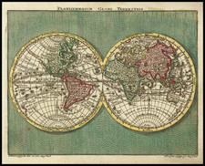


|
||

|

|
|

|
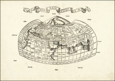
Decorative Map of the World Based Upon Claudius Ptolemy
Finely colored example of this early 16th-century map of the World according to the ancients, surrounded by 12 wind heads representing the various wind directions.
The map is drawn from the work of the Claudius Ptolemy, a Greco-Roman mathematician, astronomer, geographer and astrologer, whose Geographia, a compilation of geographical coordinates of the part of the world known to the Roman Empire during his time, would become the single most important printed cartographic work of the second half of the 15th and early parts of the 16th Century. He relied somewhat on the work of an earlier geographer, Marinos of Tyre, and on gazetteers of the Roman and ancient Persian Empire.
Ptolemy also devised and provided instructions on how to create maps both of the whole inhabited world and of the Roman provinces. In the second part of the Geography, he provided the necessary topographic lists, and captions for the maps. Ptolemy was well aware that he knew about only a quarter of the globe, and an erroneous extension of China southward suggests his sources did not reach all the way to the Pacific Ocean.
The maps in surviving manuscripts of Ptolemy's Geography, however, only date from about 1300, after the text was rediscovered by Maximus Planudes. Maps based on scientific principles had been made since the time of Eratosthenes, in the 3rd century BC, but Ptolemy improved map projections. It is known from a speech by Eumenius that a world map, an orbis pictus, doubtless based on the Geographia, was on display in a school in Augustodunum, Gaul in the third century.
In the 15th century, Ptolemy's Geography began to be printed with engraved maps; the earliest printed edition with engraved maps was produced in Bologna in 1477, followed quickly by a Roman edition in 1478. An edition printed at Ulm in 1482, including woodcut maps, was the first one printed north of the Alps.
The maps for this edition were designed by Laurent Fries for his edition of Ptolemy's Geographia, first published in 1522.
Lorenz (Laurent) Fries was born in Alsace in about 1490. He studied medicine, apparently spending time at the universities of Pavia, Piacenza, Montpellier and Vienna. After completing his education, Fries worked as a physician in several places, before settling in Strassburg, in about 1519. While in Strassburg, Fries met the Strasbourg printer and publisher Johann Grüninger, an associate of the St. Die group of scholars formed by, among others, Walter Lud, Martin Ringmann and Martin Waldseemuller.
From 1520 to 1525, Fries worked with Gruninger as a cartographic editor, exploiting the corpus of material that Waldseemuller had created. Fries' first venture into mapmaking was in 1520, when he executed a reduction of Martin Waldseemuller's wall-map of the World, published in 1507. While it would appear that Fries was the editor of the map, credit is actually given in the title to Peter Apian. The map, Tipus Orbis Universalis Iuxta Ptolomei Cosmographi Traditionem Et America Vespucii Aliorque Lustrationes A Petro Apiano Leysnico Elucubrat. An.o Dni MDXX, was issued in Caius Julius Solinus' Enarrationes, edited by Camers and published in Vienna in 1520.
Fries' next project was a new edition of the Geographia, of Claudius Ptolemy, which was published by Johann Koberger in 1522. Fries evidently edited the maps, in most cases simply producing a reduction of the equivalent map from Waldseemuller's 1513 edition of the Geographie Opus Novissima, printed by Johann Schott. Fries also prepare three new maps for the Geographie: maps of South-East Asia and the East Indies, China and the World but the geography of these derives from Waldseemuller's world map of 1507.
The 1522 edition of Fries work is very rare, suggesting that the work was not commercially successful. In 1525, an improved edition was issued, with a re-edit of the text by Wilibald Pirkheimer, from the notes of Johannes Regiomontanus. After Grüninger's death in 1531, the business was continued by his son Christoph, who seems to have sold the materials for the Ptolemy to two Lyon publishers, the brothers Melchior and Gaspar Trechsel, who published a joint edition in 1535, before Gaspar Trechsel published an edition in his own right, in 1541.
Lorenz (Laurent) Fries (ca. 1485-1532) was born in Mulhouse, Alsace. He studied medicine, apparently spending time at the universities of Pavia, Piacenza, Montpellier and Vienna. After completing his education, Fries worked as a physician in several places before settling in Strasbourg in about 1519. While in Strasbourg, Fries met the Strasbourg printer and publisher Johann Grüninger, an associate of the St. Dié group of scholars formed by, among others, Walter Lud, Matthias Ringmann and Martin Waldseemüller.
From 1520 to 1525, Fries worked with Grüninger as a cartographic editor, exploiting the corpus of material that Waldseemüller had created. Fries' first venture into mapmaking was in 1520, when he executed a reduction of Martin Waldseemüller's wall map of the world, first published in 1507. While it would appear that Fries was the editor of the map, credit is actually given in the title to Peter Apian. The map, Tipus Orbis Universalis Iuxta Ptolomei Cosmographi Traditionem Et Americ Vespucii Aliorque Lustrationes A Petro Apiano Leysnico Elucubrat. An.o Dni MDXX, was issued in Caius Julius Solinus' Enarrationes, edited by Camers, and published in Vienna in 1520.
Fries’ next project was a new edition of the Geographia of Claudius Ptolemy, which was published by Johann Grüninger in 1522. Fries evidently edited the maps, in most cases simply producing a reduction of the equivalent map from Waldseemüller's 1513 edition of the Geographie Opus Novissima, printed by Johann Schott. Fries also prepared three new maps for the Geographia, of Southeast Asia and the East Indies, China, and the world, but the geography of these derives from Waldseemüller's world map of 1507.
The 1522 edition of Fries' work is very rare, suggesting that the work was not commercially successful. In 1525, an improved edition was issued, with a re-edit of the text by Willibald Pirkheimer, from the notes of Regiomontanus (Johannes Müller von Königsberg).
After Grüninger's death in ca. 1531, the business was continued by his son Christoph, who seems to have sold the materials for the Ptolemy to two Lyon publishers, the brothers Melchior and Gaspar Trechsel, who published a joint edition in 1535, before Gaspar Trechsel published an edition in his own right in 1541.