


|
||

|

|
|

|
John Speed's Map of Asia
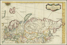
This is a fantastic map of Asia, bearing all the aesthetic strengths for which Speed's maps are prized. Asia is shown in full, with many interesting and mysterious geographical features. Eight important Asian cities line the top of this map, including Candy [Kandy], Goa [the historical, and somewhat mythological, city], Damascus, Jerusalem, Ormus [Hormuz], Bantam, Aden, and Macao. Along the sides of the map, the cultural dresses of ten civilizations can be found.
Many geographical curiosities can be found throughout this map. The Great Wall of China is prominently marked, far to the north of its true location. A lake in Tibet feeds many Bengali rivers, in an area labeled as "India without Ganges." At the source of this latter river, an elephant wanders. Korea is shown as a slender oddly projected peninsula, separated from China by a "Gulfe of Nanquin." Separating Siberia from North America is "The West Ocean," which gives way to "The Tartarian Sea" in the north.
The dresses and characteristics of the different ethnicities shown around the map are rather European. While the depictions of an Arabian, an Asyrian, and an Armenian are perhaps roughly accurate, it is clear that Speed either used inaccurate sources or just guessed for some of the others. The "Chinean" looks like an English Puritan. The Javan and the Sumatran are dressed very differently. The Tartarian resembles a Norse Viking. Further details, such as weapons that are visible, are just as inaccurate.
The text on the verso presents a fascinating anglocentric view of Asia in the early 17th century. In all, this is a great map of Asia, well designed but perhaps lacking some geographic and cultural accuracy.
John Speed (1551 or '52 - 28 July 1629) was the best known English mapmaker of the Stuart period. Speed came to mapmaking late in life, producing his first maps in the 1590s and entering the trade in earnest when he was almost 60 years old.
John Speed's fame, which continues to this day, lies with two atlases, The Theatre of the Empire of Great Britaine (first published 1612), and the Prospect of the Most Famous Parts of the World (1627). While The Theatre ... started as solely a county atlas, it grew into an impressive world atlas with the inclusion of the Prospect in 1627. The plates for the atlas passed through many hands in the 17th century, and the book finally reached its apotheosis in 1676 when it was published by Thomas Bassett and Richard Chiswell, with a number of important maps added for the first time.

![Il Disegno Della Terza Parte Dell' Asia [Gastaldi's Wall Map of SE Asia with extra panels!]](https://storage.googleapis.com/raremaps/img/small/30554hbp.jpg)
![[ Ptolemy's Asia ] Asien nach Ptolemaeos](https://storage.googleapis.com/raremaps/img/small/97369.jpg)