|
||

|

|
|

|
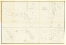
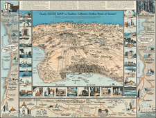
A Los Angeles County Rarity From An Early Los Angeles Surveyor, County Assessor and Fraudster
Rare early map of Los Angeles County, created by H. J. Stevenson and lithographed by C. L. Smith of Oakland in 1880.
The present map is one of the earliest surviving maps of Los Angeles County and one of the rarest. The map is colored by "Townships." This is the first map we have ever seen which applies the concept of a township to Los Angeles County.
The map provides the names of a number of smaller Ranchos and early land owners. For example, J. Irivine is listed as the owner of a large portion of Santa Ana Township. In several areas, small town grids are shown, including Los Angeles, Santa Monica and South Santa Monica, Pasadena, Colton, San Bernardino, Riverside, Pomona, Spadra, Downey, Artesia, Anaheim, Wilmington, Westminster, Santa Ana, Tustin, Newport and Capistrano.
The Los Angeles & Independence Railroad is shown connecting Los Angeles and Santa Monica, with the Southern Pacific between LA and Colton and then headed north to Tehachepi, and the Los Angeles and San Pedro to the south, with an Anaheim Branch terminating in Santa Ana.
The map includes an inset of Catalina and San Clemente Islandsa, along with a distance key.
H. J. Stevenson was a Civil Engineer and Surveyor, who rose to become Los Angeles County Surveyor and Los Angeles County Surveyor.
Canadian by birth, Stevenson attended Washington County Seminary and Collegiate Institute in New York from 1861-62. From 1862-64 he was a chainman and axeman for George House and George Sloan in Port Angeles. He received his own survey contract in Washington Territory in 1864. By 1869 he was in Portland, Oregon .Between 1869 and 1874, he worked as a surveyor, serving as Portland City Surveyor from 1869-1872.
By late 1874, he had relocated to Los Angeles and was advertising as a surveyor. He received an appointment as a U. S. Deputy Surveyor in California to examine improvements on Rancho Santa Monica in 1876. In 1879, Stevenson ran for State Surveyor General of California on the Workingman Ticket and lost.
From 1884-87 Henry was involved in speculative real estate development, selling acreage and lots. He suffered several business and personal foreclosures in 1888-89. By the late 1880s, Stevenson's fortunes had changed dramatically, as he apparently became the mastermind of a land fraud scheme which would become known as the "school-lands scheme." As described by the Los Angeles Times on March 10, 1888,
There is no denying the fact that there is something radically wrong, and hardly a day passes without letters being received by the Government land officials here, making inquiries about this and that section of land which has been located by parties in other sections of the State, which are shown by the maps to be in wild and impracticable moutains, lave beds or desert land, utterly worthless. The Register of the Land Office has received at least a hundred such letters in the past month . . .
Stevenson's scheme seems to have also employed the use of unwitting strawman agents, whom he persuaded to hold title to the land, before selling it to the ultimate victims. He was listed as a surveyor in the censuses in Los Angeles in 1900, 1910 and 1920, and was noted as surveying several large ranches into developments over the years in Southern California.
Rarity
The map is of the utmost rarity. OCLC locates examples at the Bancroft Library, California Historical Society and Newberry Library.
We find no record of the map appearing on the market in any auction or dealer catalog.
![[Oregon / Mount Hood / Columbia River to Bodega Bay] Cote Nord-Ouest De L'Amerique Reconnue par Cape. Vancouver 2e. Partie . . .](https://storage.googleapis.com/raremaps/img/small/82223.jpg)