|
||

|

|
|

|
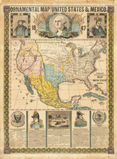
A Masterwork of Mexican Chromolithography and Artistic Mapmaking.
Beautiful chromolithographed wall map of Mexico, by the country's greatest 19th-century mapmaker, Antonio Garcia y Cubas.
The name "Oro-Hidrografica" might initially bring to mind gold, however, in this context it actually relates to orography, the branch of physical geography concerned with mountains.
Garcia y Cubas was a true mapmaker-artist; in his maps, the geography is often accentuated by and plays host to his exceptional aesthetic talents. Thus the mapping of mountains and waterways lends itself to Garcia y Cubas's considerable visual talents and the wall map he composed here is the magnum opus of his visual style.
To bring the map to fruition, he relied upon the talents of chromolithography firm Victor Debray y Companía, with which he had partnered on other projects as well. According to W. Michael Mathes, Mexico on Stone (page 18), Victor Debray y Cía was responsible for "some of the finest examples of the lithographer’s art during the latter part of the century". This is no doubt the case; the multi-stone lithography of the present map rivals that of what was being produced in Germany, Great Britain, New York, and San Francisco during the last decades of the 19th century.
The map shows much of the southern and southwestern United States as well as Mexico. Texas is almost completely - and very attractively - rendered.
As with most maps of the period, there is a significant emphasis on transportation infrastructure. Namely, steamships and railroads.
In the lower-left of the map is an inset of the region between Veracruz and Mexico City. That map is titled "Plano Orografico de la Zona Recorrida Por El Ferro-Caril Mexicano de Veracruz a Mexico."
Editions and Rarity
Rare late edition of Antonio Garcia Cubas's monumental wall map of Mexico,
We note that the famed American Railroad Financier Jay Gould held a copy of the1879 edition of the map in his library.
OCLC records 3 states of the map:
- 1878: British Library and University of Wisconsin Milwaukee (American Geographical Society Collection). To this, we can add the Mapoteca Manuel Orozco y Berra and the John Martin Davis Jr. Collection, Museum of the Big Bend.
- 1879: Cambridge University and Northwestern University
- 1893: University of California Berkeley
Though the map must have been popular in its day--having gone through at least 3 editions--it is extremely rare now. RBH records no other examples at auction, nor does oldmaps.com, nor can we find any other examples having been offered for sale.
Antonio García y Cubas (1832-1912) was a Mexican geographer, historian, writer, and cartographer. An orphan from a young age, Cubas attended the Colegio de San Gregorio and the Colegio de Ingenieros, where he earned a geography degree. In 1856, he became a member of the Sociedad Mexicana de Geografía y Estadística.
Cubas wrote several geographic works, including introductory courses to geography, historical atlases, and maps. He is best known for his Atlas Geográfico, Estadístico e Histórico de la República Mexicana (1857), Carta General de México (1863), and Diccionario Geográfico, Histórico y Biográfico de los Estados Unidos Mexicanos en cinco volúmenes, editados entre 1888 y 1891. He is also praised for his memoir, El Libro de mis Recuerdos (1905). Today, the best books published in anthropology and history in Mexico are given the Antonio García Cubas prize.
![(Van Zandt County, Texas) [Preemption Land Grant, signed by Elisha M. Pease,1857 - Texas Land Grant on Kickapoo Creek in Nacogdoches District, Van Zandt County] Preemption. In the Name of the State of Texas](https://storage.googleapis.com/raremaps/img/small/92651.jpg)

![The Rise, Progress and Prospects of the Republic of Texas [including:] Map of Texas, compiled from Surveys recorded in the Land Office of Texas, and other Official Surveys, By John Arrowsmith. [and:] A Map of the Republic of Texas and the Adjacent Territories, Indicating the Grants of Land Conceded under the Empresario System of Mexico.](https://storage.googleapis.com/raremaps/img/small/94046.jpg)
![[Southern Arizona - Sonora] (Restricted) Douglas . . . Sectional Aeronautical Chart](https://storage.googleapis.com/raremaps/img/small/96226.jpg)