|
||

|

|
|

|
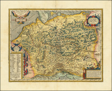
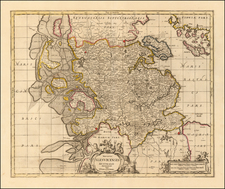
This is a very attractive antique map of Germany, representing the power of the Holy Roman Empire, and the extent of German peoples. The map covers not only present-day Germany, but other lands with substantial German populations including Austria, Lorraine, the Palatinates, northern Switzerland, Tirolia, and Mazovia. This makes for a fascinating look at the history of north-central Europe.
The detail on the map is extensive. Hundreds of towns are shown alongside geomorphological detail such as mountains, forests, and rivers. Political divisions are shown. Many of the great cities of Europe can be found on this map which stretches from westernmost Flanders to Bosnia.
Adorning the top of the map are eight coats of arms, centered on the larger crests of the Holy Roman Emperor and of Bohemia. The crests of the provinces of Brandenburg, Saxony, Paltz, Mainz, Coln, and Trier are also shown. An attractive cartouche resides in the lower left.
The ascription of this map to the region of "Germaniae" and "Teutschland" is particularly interesting. In the middle of the 17th century, the idea of a German state was yet to appear. The Holy Roman Empire was disjointed politically, linguistically, and religiously. This was especially evident during the period of the Thirty Years' War when this map was made. The map likely refers more to the extent of German people, something with interesting cultural implications for 17th-century German thought. Maps explicitly focused on the extent of German peoples and Pan-Germanism would come into their own in the 19th century, and reach their zenith in the early days of Nazi propaganda.