|
||

|

|
|

|
A Fascinating Map of an Uncertain Pacific Northwest
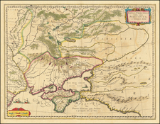
This is an interesting map centered on the northwest coast of America, and extending from Siberia to Greenland. Not just one, but many Northwest Passages are shown in this map dedicated to the cartographic debates of the era.
This area was cartographically contentious enough that Diderot dedicated most of his ten-map Enyclopedie supplement to the region so as to be able to show the various possibilities. This map eschews the more realistic nature of the other maps in the work, and shows many myths regarding the region. Despite this, parts of the map, especially in Alaska, are accurate for their time and based on the cutting-edge Jeffrey's map.
Prior to Cook's first voyage, English, French, and Russian cartographers were actively debating the cartography of the region in the North Pacific between Asia and North America. The Russian explorations of the first half of the 18th century, including those by Bering, Tchirikow, and others, had been reported by De L'Isle, who had worked with the Russians and was privy to their latest discoveries. These reports were used by Jeffreys, who is cited as a key source in this map.
To the east of Alaska, the somewhat realistic cartography gives way to a mythic portrayal. Diderot shows many interesting features and notes who discovered or mapped them. Off the coast of a northern horn of Alaska (as indicated by the Japanese), the islands of Ye-Oue can be found, where the pygmies supposedly reside. No Sea of the West is shown, and the Straits of Juan de Fuca are narrow and reach the Atlantic just north of Hudson Bay. Many other rivers and lakes create additional circuitous Northwest Passages. The River of the West, forerunner of the Columbia, is shown with at least two different possibilities, after Russian and French maps. Diderot cites an Indian cartographer "Ochagach" as indicating a mountain chain with translucent rocks, near the location of the Rocky Mountains. A reference is even made to the Chinese Fusang. Evidently, the map is very well researched, and is one of the best collections of cartographic myths on a single work from the 18th century, rivaling Buache's maps, from which Diderot obviously drew some inspiration.
If Ortelius is the father of the modern atlas, Diderot is the creator of the encyclopedia as we know it. His Encyclopédie sought to act as a reference work for useful human knowledge and is widely accepted as being the first modern encyclopedia. This work is considered one of the most important texts of the Enlightenment and was compiled by many contributors, known as Encyclopédists. Topics covered in the work included units of measurements, the Arts Mechaniques, agriculture, and many, many other topics.
The Encyclopédie was notable for many reasons. Not only did it create the modern encyclopedia as we know it, as well help move the ideas of the Enlightenment along, but it was also politically important. Some contributors openly attacked the Catholic Church and the French Monarchy (while others defended these institutions), and Clement XIII placed it on the Index. Despite Diderot's perception that, during his lifetime, the work was pointless, the Encyclopédie is now seen as one of the forerunners of the French Revolution.
Gilles Robert de Vaugondy (1688-1766) and Didier Robert de Vaugondy (1723-1786) were influential figures in the realm of 18th-century French cartography. Originating from Paris, their contributions to mapmaking were significant during an era of expansive geographical exploration.
Gilles Robert de Vaugondy entered the world of cartography not through family tradition but through personal interest and the budding opportunities of his time. Born in 1688, he worked during a time when Paris was becoming a central hub for cartographic activities. Gilles often incorporated the latest findings from explorers into his maps, making them sought-after for their contemporary relevance. His connections weren't limited to his immediate circle; he frequently interacted with other key mapmakers, staying updated on the latest techniques and findings.
His son, Didier, was born in 1723 and had the advantage of growing up surrounded by maps and globes. While his father was renowned for maps, Didier made a name for himself in the field of globemaking. His globes were some of the most precise and detailed in France, gaining recognition even among the royalty. In addition to his work in cartography and globemaking, Didier had a keen interest in education, especially after the expulsion of the Jesuits from France. He stepped in to produce geographical educational materials, fulfilling a newfound need.
The maps and globes produced by the Vaugondys remain an enduring testament to the peak of French cartography during the Enlightenment. Their works, characterized by precision and the inclusion of contemporary findings, helped to shape our understanding of the world during a transformative period in European history.