|
||

|

|
|

|
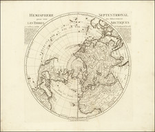
Scarce late state of Guillaume De L'Isle's map of the Western Hemisphere, updated to include the 3 voyages of Captain James Cook.
Dezauche also shows the route of the voyages of Abel Tasman (1642), Quiros, Magellan (1520), Le Maire (1616), Mendana (1568 and 1595). Davis's sighting of Icebergs southwest of the Straits of Magellan is noted, and the later voyages of Halley (1700), St. Louis (1708), Le Maire (1738) and Le Lion (1756) are also noted. In the North Pacific, the routes of Gaetan (1542), Tchirikow (1741) and the St. Antoine (1710) are noted.
The most notable changes from prior editions include:
- Updated mapping of New Zealand, which is no longer attached to the unknown southern continent.
- The mythical antarctic continent has been removed.
- Conjectural Northwest Passage is now combined with Cook's treatment of Alaska and the Pacific Northwest
- The Sea of the West is removed
- Hawaii is shown (Isles Sandwich)
Philippe Buache (1700-1773) was one of the most famous French geographers of the eighteenth century. Buache was married to the daughter of the eminent Guillaume Delisle and worked with his father-in-law, carrying on the business after Guillaume died. Buache gained the title geographe du roi in 1729 and was elected to the Academie des Sciences in the same year. Buache was a pioneering theoretical geographer, especially as regards contour lines and watersheds. He is best known for his works such as Considérations géographiques et physiques sur les découvertes nouvelles dans la grande mer (Paris, 1754).