


|
||

|

|
|

|
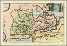
A fascinating map of the Middle East, produced by the Army Corps of Engineers for briefing purposes. The region shown extends from southeastern Turkey to Saudi Arabia and shows parts of the nations of the United Arab Republic [Egypt], Israel, Cyprus, Syria, Lebanon, Jordan, and Iraq. The map is clearly focused on the area around Israel, showing a region that would soon see armed conflict.
There is little doubt that this map was produced due to the mounting tensions present in the lead up to the 1967 Six-Day War. The 1960s saw widespread distrust in the region left behind by the poorly resolved Suez Crisis, and anti-Israel alliances were formed between Arab states. The Straits of Tiran, here labeled on the map, were particularly contentious. The Israeli military issued an ultimatum that any closure to the straits would lead to war. This would escalate when Egyptian troops were deployed defensively to the Sinai peninsula based on false information, leading the Israeli military to believe that they were about to close the straits. Israel then immediately launched pre-emptive strikes on all neighboring Arab nations. The war would be brief and change the outline of Israel, giving it control of the West Bank and Golan Heights. Tensions would simmer until the Yom Kippur war six years later.
A map like this would have been used to supplement briefings given to American presidents and military leaders in the days before the outbreak of war. The date of creation of this map can be constrained by the independence of Syria and the Israeli-Jordan boundaries, providing a date between 1961 and 1967, but it was more likely produced near the end of this period.
![(Nuremberg Chronicle) [Geneology of the Virgin Mary]](https://storage.googleapis.com/raremaps/img/small/98722.jpg)
![Syria (North Division) [with] Syria (South Division) including Palestine & the Hauran.](https://storage.googleapis.com/raremaps/img/small/89072.jpg)
![[An Irgun Modified Map of Palestine and the Middle East]](https://storage.googleapis.com/raremaps/img/small/68844.jpg)

![Carte Particuliere d'une Partie d'Asie ou sont Les Isles D'Andemaon, Ceylan, Les Maldives . . . [with] Partie Occidentale d'une D'Asie ou sont les Isles De Zocotora De l'Amirante . . .](https://storage.googleapis.com/raremaps/img/small/99858.jpg)