|
||

|

|
|

|
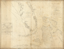
This is a detailed navigation chart of the Florida Coast from Sapelo to Lucie Sounds and extending east to the Little Bahama Bank. The map shows St. Augustine, Jacksonville, Daytona Beach, Fort Gatlin (but neglects to mention Orlando), and Melbourne. Inland, the map has some detail, including railroads, swamps, lakes, and rivers. The detail of the railroads into the interior is rather impressive.
The interior is practically filled with Seminole War-era forts including Fort Fraser, Fort Cummings, Fort Davenport, Fort Gatlin, Fort Maitland, Fort Mason, Fort Brooks, Fort Pierce, Fort Capron, and Fort Lloyd.
At sea, the detail is extensive on this map. Named and labeled are soundings, banks, shoals, harbors, inlets, and much more. Tidal information is provided, with the range of tides shown for several different localities. On the map, notes are provided regarding currents and other hazards.
As with all U.S. Coast Survey charts, this map provides a wealth of information while preserving a simple and attractive design.
The United States Office of the Coast Survey began in 1807, when Thomas Jefferson founded the Survey of the Coast. However, the fledgling office was plagued by the War of 1812 and disagreements over whether it should be civilian or military controlled. The entity was re-founded in 1832 with Ferdinand Rudolph Hassler as its superintendent. Although a civilian agency, many military officers served the office; army officers tended to perform the topographic surveys, while naval officers conducted the hydrographic work.
The Survey’s history was greatly affected by larger events in American history. During the Civil War, while the agency was led by Alexander Dallas Bache (Benjamin Franklin’s grandson), the Survey provided the Union army with charts. Survey personnel accompanied blockading squadrons in the field, making new charts in the process.
After the Civil War, as the country was settled, the Coast Survey sent parties to make new maps, employing scientists and naturalists like John Muir and Louis Agassiz in the process. By 1926, the Survey expanded their purview further to include aeronautical charts. During the Great Depression, the Coast Survey employed over 10,000 people and in the Second World War the office oversaw the production of 100 million maps for the Allies. Since 1970, the Coastal and Geodetic Survey has formed part of the National Oceanic and Atmospheric Administration (NOAA) and it is still producing navigational products and services today.
![[Florida / Bahamas] . . . Mosquito Inslet to Key West. . . 1863](https://storage.googleapis.com/raremaps/img/small/75869.jpg)