|
||

|

|
|

|
"Why would you not live without your joyous protector, O Pomerania, region that justly mourns the loss of its Palatine?"
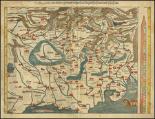
A scarce map of Pomerania, stretching along the coast from present-day eastern Germany to the outskirts of Gdansk in modern Poland. To the south, the map nearly reaches Berlin. The map is detailed, showing many rivers, towns, place names, political divisions, and more. The map includes two decorative cartouches and a scale bar.
Pomerania was bitterly fought over during the Scanian War, waged between the Holy Roman Empire and Denmark-Norway against Sweden and France. During a prolonged campaign, Sweden initially tried to invade Brandenburg-Pomerania but ended up losing Swedish Pomerania instead. The region became part of the Holy Roman Empire for several years, but Fredrick William I was forced to cede his gains in Pomerania at the end of the war in the 1679 Treaty of Saint-Germain-En-Laye. Pomerania would again change hands many times in the half-century after this map was made.
The cartouche in the bottom left of the map is very intriguing. In it, Rossi addresses Pomerania, personifying the province, and refers to the recent political upheavals in the region. He states that despite the recent changes in territory, his "geographic Mercury" dictates that he shall portray it all as part of the V. E., perhaps a reference to the Holy Roman Empire. He himself "bows" to this entity. This almost certainly refers to the Treaty of Saint-Germain-En-Laye. The cartouche also dedicates itself to Domenico Maria Corsi, Cardinal of Romagna. Rossi is evidently trying to gain favor here, though the relation between Cardinal Corsi and Pomeranian politics is uncertain, as there are no obvious religious or political implications.
Giacomo Giovanni Rossi (1627-1691) was an Italian engraver and printer. He worked in Rome, the heir to an important printing business founded by his father, Giuseppe de Rossi (1570-1639). Giuseppe began the press in 1633 and Giovanni and his brother, Giandomenico (1619-1653) took it over upon his death. The brothers expanded the business and by the mid-seventeenth century it was the best-known printing house in Rome.
For his maps, Giovanni worked with Giacomo Cantelli da Vignola. They produced the Atlas Mercurio Geografico. The first edition is undated, but the second was issued in 1692, a year after Giovanni’s death. The maps were by Cantelli. The firm also published maps based on those of Nicolas Sanson.
Later, the business passed to Lorenzo Filippo (1682-?). By 1738, the firm was known as Calcografia Camerale, then, from 1870 to 1945, as the Regia Calcografica. Today, the firm is still in business and is called Calcografia Nazionale. It operates as a free museum and offers one of the best collections of prints and plates in the world.
![[ Siege of Krakow ] Was gestalt des Koniges in polen Sigismundi Braut Anna Caroli, Ertzhertzogen Von Osterreich Christmilter gedechnus Tochter, den 28 Mayus. 92 bij Crocaw . . .](https://storage.googleapis.com/raremaps/img/small/98964.jpg)
![[ Holy Roman Empire ] Germania, Non ea tantum quae Rheno, Vistula, Danubio, mariqz Germanico Veteribus claudebatur; Sed tota illa continens quae hodie communiter Germanica lingua utitur . . .](https://storage.googleapis.com/raremaps/img/small/99236.jpg)