|
||

|

|
|

|
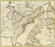
An interesting 18th-century map of the United States, published by J. Wilkes in London in 1797.
The map shows the United States in the decade after the American Revolution.
Unusual Early Federal Land Designations
In the South, both East Florida and West Florida are located, with Georgia extending from the Atlantic to the Mississippi River, prior to the creation of Mississippi Territory.
- "Indiana"
A proposed area of "Indiana" is shown as a carveout from Virginia, roughly equivalent to modern-day northern West Virginia. - "Tenassee Government" and "Reserved for N. Carolina Troops"
The name "Tenassee Government" appears, just a few years after the creation of Tennessee. A section of Tennessee is shown as "Reserved for N. Carolina Troops", which were lands set aside for North Carolina soldiers who fought in the American Revolution, their families, and the surveyors who first mapped the lands. - "Land reserved for Virginia Troops"
A similar reserve existed in Kentucky for Revolutionary War soldiers from Virginia. Both of these arrangements reflected the historical inclusion of those states into the colonies that lay to their east. - "N. Jersey Compy.", "Illinois Com", "Wabash Com", "Army Ls."
West of Kentucky on the Mississippi River, the N. Jersey Company is named, along with Wabash Company and Illinois Company above it, all part of the Land Schemes which helped open up the Ohio River Valley. - "Divided into 10 States by a Resolve of Congress 1784"
In modern Illinois, there is a reference to "Divided into 10 States by Resolve of Congress 1784." This is likely a reference to Thomas Jefferson's proposal for the region, which included the states of Sylvania, Michigania, Illinoia, Saratoga, Washington, Chersonesus, Assenisipia, Metropotamia, Polypotamia, and Pelisipia. - "G. Clark's Grant 150,000 Acres"
The map also notes G. Clarke's Grant of 150,000 acres, north of the Ohio River in Indiana. During the American Revolutionary War, George Rogers Clark led the militia of Virginia in capturing a large part of the Illinois Country as part of the Illinois Campaign. Land was offered as an incentive to adventurers to sign up as soldiers and join the expedition. After the war ended, as a reward, Virginia granted the soldiers and officers land to make good their promise.The grant was made by the legislature of Virginia on January 2, 1781, offering them land on the northwest side of the Ohio River. A commission of officers from the group was created and they were granted the right to choose any 150,000 acres within the defined region. They chose a tract across the Ohio River opposite from Louisville, Kentucky, a settlement Clark had founded during the war. Their land included all of present-day Clark County, Indiana, as well as part of the surrounding counties. The group took part in land speculation and they ultimately purchased the rights to a large part of southern Indiana. Early settlements in the grant included Clarksville and Jeffersonville.
Clark himself was still owed a vast sum of money for helping to finance the campaigns which was never repaid to him during his life. Most of his land was taken from him by creditors, and he died nearly penniless and handicapped from injuries he sustained after the war. Virginia finally repaid most of his debt several years after his death.
- "Donation LD. from Virginia Commonwealth", "Army Ld.", "Ohio Compy.", "7 Ranges"
Below Lake Erie, the Ohio Company lands are shown, along with an early representation of the Seven Ranges.
Charles Wilkes (1798-1877) was a skilled naval surveyor and the commander of the United States South Seas Exploration Expedition (U.S. Ex. Ex.), the largest scientific voyage ever mounted by the United States. Wilkes was born in New York City and began to sail in merchant vessels from 1815-1917.
Wilkes joined the United States Navy as a midshipman in 1818; by 1826, he had risen to the rank of lieutenant. Fascinated by hydrography, Wilkes studied triangulation and surveying with Ferdinand Hassler, the first superintendent of the United States Coast Survey. This expertise and initiative led him to be named Director of the Navy’s Depot of Charts and Instruments in 1833.
After being stalled by the Navy, U.S. Ex. Ex.—the U.S. response to the scientific voyages of Cook and La Perouse—was finally preparing to sail in the late 1830s. Wilkes was offered command, thanks to the heavy surveying focus on the voyage. He was given command of six vessels and nine scientists. However, the ships were not well supplied and the expedition was executed with some difficulty.
The ships left Norfolk in August 1838. They went in convoy to Tierra del Fuego, where they split and some explored in the South Seas and others in the South Atlantic. In late 1830, Wilkes surveyed portions of Antarctica that today are named for him (Wilkes Land). From spring 1840, the ships explored the mid- and North-Pacific. In June 1842, Wilkes returned to New York Harbor with only two of his six ships and a mountain of ethnographic, botanical, and natural historical specimens, as well as reams of observations, drawings, and charts.
Wilkes was met with a court martial; while he was acquitted of most charges, he was convicted of illegal punishment and reprimanded by the Secretary of the Navy. Despite this, he was promoted commander in 1843, captain in 1855, and commodore in 1862.
Wilkes spent much of his remaining career overseeing the publications of the expedition. The first official publication to appear was Wilkes’ rambling five-volume narrative of the voyage, accompanied by a folio atlas, in 1844. A further 19 volumes were prepared over the course of 30 years, each on a different scientific topic, although only 14 were ever distributed. Perhaps the most impressive legacies of the expedition were the almost 250 charts Wilkes prepared in two atlases (completed 1858, published 1861, but not distributed until after the Civil War). These formed the basis of the United States Hydrographic Office.
Wilkes served in the Union fleet in the Civil War. In 1864 he was before a court-martial again, this time for the publication of a private letter to the Secretary of the Navy. He was found guilty. He retired two years later, in 1866, and died in Washington D. C. in 1877.
![Trails: [1595-1945]: Land, Sea, and Air of The American Adventure Series](https://storage.googleapis.com/raremaps/img/small/70672.jpg)
![(American Revolution) Geschichte der Revolution von Nord-America. Sammlung der besten Schriftsteller, welche die Geschichte, besondere Rechten, Sitten, und Gewohnheiten der Völker nach ihren Grundsätzen abgehandelt haben [with map:] Die Vereinigten Staaten von Nord=America. nach der Wm. Faden 1783. [History of the Revolution of North America. Collection of the Best Writers Who Have Discussed the History, Specific Laws, Customs, and Habits of the Peoples According to Their Principles [with map:] The United States of North America. According to Wm. Faden, 1783.]](https://storage.googleapis.com/raremaps/img/small/90124.jpg)
![(Coast of Florida, Georgia and the Carolinas] [To The Members Of The Nautical Institution And Ship-Masters' Society Of The City Of New York, This Chart, Extending From Lat. 40°15 N., Long. 72°15 W., to Lat. 22°35 N., Long. 80°25 W., Is Respectfully Dedicated / By Their Obedient Servant Edmund M. Blunt]](https://storage.googleapis.com/raremaps/img/small/77294.jpg)