|
||

|

|
|

|
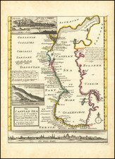
Decorative and detailed map showing Central Asia and the Tartary, from Chatelain's monumental 7 volume Atlas Historique.
The map extends from Nova Semla in the northwest towards northern China and the peninsula of Korea in the southwest of the map. Includes many place names, rivers, lakes, mountains, etc.
Henri Abraham Chatelain (1684-1743) was a Huguenot pastor of Parisian origins. Chatelain proved a successful businessman, creating lucrative networks in London, The Hague, and then Amsterdam. He is most well known for the Atlas Historique, published in seven volumes between 1705 and 1720. This encyclopedic work was devoted to the history and genealogy of the continents, discussing such topics as geography, cosmography, topography, heraldry, and ethnography. Published thanks to a partnership between Henri, his father, Zacharie, and his younger brother, also Zacharie, the text was contributed to by Nicolas Gueudeville, a French geographer. The maps were by Henri, largely after the work of Guillaume Delisle, and they offered the general reader a window into the emerging world of the eighteenth century.
![[ Pacific Ocean and America -- The West Indies ] Descripcion De Las Yndias Ocidentales](https://storage.googleapis.com/raremaps/img/small/95683.jpg)
![(China) КАРТА КИТАЙСКAГО ГОСУДАРСТВА. [Map of the Chinese State.]](https://storage.googleapis.com/raremaps/img/small/56505.jpg)