


|
||

|

|
|

|
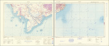
A fascinating image of South Vietnam, a decade into American involvement in the region. The main portion of the map focuses on the US military establishments in the country. Command headquarters, helicopter bases, navy bases, and other points of interest relating to allied forces can be found. In addition, the Ho Chi Minh Trail is marked snaking through Laos and Cambodia, entering Vietnam at several different points.
Insets on the map provide more information regarding the war. One inset shows the many provinces of South Vietnam, while three insets detail the size of US forces and casualties of the war. The map specifically refers to the amount of US service members killed in the year since peace talks began in May of 1968. The US would not withdraw militarily until 1973.
This map features alongside several other maps of interest and was almost certainly produced for use by journalists. This map was separately issued for the AP's "Background Map service."
Other maps and works shown on this sheet detail US military installations in Japan, the World Communist Conference which occurred in Moscow on June 5th, and global population growth. The poster on population growth advertises that by 2069 Costa Rica, the then fastest-growing nation, will have 75 million inhabitants if current trends continue.
![Rangoon [Yangon, Birmah]](https://storage.googleapis.com/raremaps/img/small/90251.jpg)
![[South Vietnam & Cambodia] Carte de la Cochinchine . . . Dressee au Bureau Topographique Des Troupes De L'Indo-Chine Fevrier 1890](https://storage.googleapis.com/raremaps/img/small/62547.jpg)