|
||

|

|
|

|
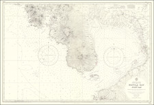
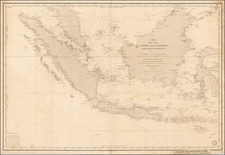
This is an attractive navigational chart of Manila Bay, showing a very small city of Manila. The map spans a large area, from Mariveles to Laguna de Bay. An inset map shows Port Cavite and the present-day location of Cavite City in detail. Navigational detail on the map is extensive, showing many soundings, shoals, inlets, lighthouses, banks, and much more. Inland detail is also shown, with cities, elevations, rivers, and more marked.
Manila proper is but a tiny city on this map. The outline of the city takes the form of Intramuros, with its distinctive fortifications easily recognizable. Manila Cathedral is labeled at the north end of the walled city. Several other towns are labeled in the proximity of the city, including Malate, Binondo, and Tondo, which now name the neighborhoods of Manila. Cavite City is nearly as large and important as Manila was, with its own fort. In the present, Cavite Fort has now been replaced by a shipyard, though some parts of old Cavite still do exist.
The Philippines had long been a focus of colonial powers at the time this map was made. France had always been particularly close to the Spanish colony and was the first foreign nation to establish a consul there in 1824. Trade was common between the two nations, with France traders buying goods from elsewhere in Asia which passed through the city and selling high-end goods to Spanish settlers. Trade would only increase with the completion of the Suez Canal in the same year that this map was updated.
As with all Depot de la Marine charts, this map provides a wealth of information while preserving a simple and attractive design. This map was sold separately.
The Dépôt de la Marine, known more formally as the Dépôt des cartes et plans de la Marine, was the central charting institution of France. The centralization of hydrography in France began in earnest when Jean-Baptiste Colbert became First Minister of France in 1661. Under his watch, the first Royal School of Hydrography began operating, as did the first survey of France’s coasts (1670-1689). In 1680, Colbert consolidated various collections of charts and memoirs into a single assemblage, forming the core of sources for what would become the Dépôt.
The Dépôt itself began as the central deposit of charts for the French Navy. In 1720, the Navy consolidated its collection with those government materials covering the colonies, creating a single large repository of navigation. By 1737, the Dépôt was creating its own original charts and, from 1750, they participated in scientific expeditions to determine the accurate calculation of longitude.
In 1773, the Dépôt received a monopoly over the composition, production, and distribution of navigational materials, solidifying their place as the main producer of geographic knowledge in France. Dépôt-approved charts were distributed to official warehouses in port cities and sold by authorized merchants. The charts were of the highest quality, as many of France’s premier mapmakers worked at the Dépôt in the eighteenth century, including Philippe Bauche, Jacques-Nicolas Bellin, Rigobert Bonne, Jean Nicolas Buache, and Charles-François Beautemps-Beaupré.
The Dépôt continued to operate until 1886, when it became the Naval Hydrographic Service. In 1971, it changed names again, this time to the Naval and Oceanographic Service (SHOM). Although its name has changed, its purpose is largely the same, to provide high quality cartographic and scientific information to the France’s Navy and merchant marine.