|
||

|

|
|

|
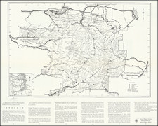
Showing Franklin Territory (Nebraska) and Jefferson Territory (Dakota)
Highly detailed and meticulously researched map of the Western United States, published in J.M. Ziegler's Geographischem Atlas.
This is one of the finest atlas maps of the west we have ever encountered, incorporating exceptional detail throughout, with more roads, rivers, settlements, Indian names and other features than most maps of the period.
In California, a number of mountains and mountain passes are named. As noted below, the treatment of the Commanche frontier forts In Texas is quite remarkable.
The topographical details in New Mexico Territory are quite exceptional. The nascent Arizona Territory appears below New Mexico, a forerunner to the so called Baylor Line, which would have made Arizona Territory a Slave Territory.
In Indian Territory and Kansasa, a number of the rivers near the the Arkansas shown are given their Indian names.
In Nebraska Territory, Fort Laramie and Fort Grattan are shown. The records of the war department show that Fort Grattan was established at Ash Hollow, on the Oregon route 188 miles west of Fort Kearney, September 8, 1855, and abandoned October 1, 1855. On the Missouri River, Fort Randall (1856), Fort Lookout (1856), Fort George and Fort Pierre are shown.
Dakota or Jefferson Territory
The depiction of "Dakota oder Jefferson Ter." would appear to relate to the period between 1859 and 1861, where various proposals were made to create what would be come Colorado Territory. In 1858, discovery of gold in what is now Colorado resulted.in a rush of settlers into the region. The next year, in a move for self-government typical of several other frontier settlements in American history, the residents of the area created "Jefferson Territory," an unofficial political entity. Two years later, in 1861, Colorado was organized as a "territory including those lands which make up its present boundaries, that is, parts of the territories of Utah, Kansas, Nebraska, and New Mexico. "Jefferson Territory" came to an end when the territory of Colorado was created.
Nebraska or Franklin Territory
This reference is a mystery.
Frontier Texas Forts
In the late 1840s and early 1850s, a number of forts were established in Western Texas to protect settlers from Indian raids. A number of these forts lasted for only a few years and are rarely depicted on printed maps.
Fort Terrett (called Fr. Territt on the map) was a U.S. Army post from 1852–1854, later the site of a ranch, an historic locale in Sutton County, Texas, United States. Originally named “Post on the Rio Llano or Post on the North Fork River Llano and Camp Lugubre”, it was renamed in 1852 after Lt John Terrett. Terrett was killed in the Battle of Monterrey in 1846. Lt. Col. Henry Bainbridge established the camp in February 1852 for protection for the settlements and travelers along the Upper San Antonio Road. The post was abandoned on February 1854, with the troops locating farther to the west and north on the advancing frontier. The fort buildings were then used for the Noel Ranch.
Fort Merrill was a U.S. Army post established in 1850, by Captain Samuel M. Plummer and companies H and K of the 1st U.S. Infantry and named after Captain Moses E. Merrill, who was killed in September 1847 at the Battle of Molino del Rey during the Mexican War. Fort Merrill was abandoned in 1855.
Fort Duncan was established on March 27, 1849, when Captain Sidney Burbank occupied the site with companies A, B, and F of the First United States Infantry. On November 14, 1849, the post was named Fort Duncan, after Col. James Duncan, a hero of the Mexican–American War. It was abandoned in 1883.
Fort Inge: Established as Camp Leona on March 13, 1849, Fort Inge was garrisoned intermittently until March 19, 1869. The fort served as a base for United States Army troops assigned to protect the southern overland mail route along the San Antonio-El Paso Road from Indian raids. The camp was renamed Fort Inge in honor of Lieutenant Zebulon M. P. Inge a West Point officer killed in the Mexican–American War.
Fort Ewell was established May 18, 1852 by Ltc. William W. Loring, and six companies of the U.S. Mounted Riflemen, and named for Capt. Richard S. Ewell, a veteran of the Mexican-American War who was then 1st lieutenant of the 1st U.S. Dragoons. The fort was commanded by Captain and Brevet Major John Smith Simonson and occupied by a two-man medical department and three companies of the U.S. Mounted Riflemen, E, G, and I. The fort was abandoned on October 3, 1854.
Fort Martin Scott was a United States Army outpost near Fredericksburg in the Texas Hill Country, United States, that was active from December 5, 1848 until April, 1853. It was part of a line of frontier forts established to protect travelers and settlers within Texas.
Fort McKavett was a frontier fort established as Camp on the San Saba in 1852 to protect settlers from Indian raids. The camp was renamed in honor of Captain Henry McKavett, who was killed in the Mexican–American War battle of Monterrey.
Fort Lancaster was established by Captain Stephen Decatur Carpenter on August 20, 1855, to guard the military supplies, commercial shipments, and immigrants moving along the San Antonio-El Paso Road. It was abandoned in 1873 or 1874.
Fort Chadbourne was established by the United States Army on October 28, 1852, to protect the western frontier and the Butterfield Overland Mail route. It was named after Lt. T.L. Chadbourne, who was killed in the Battle of Resaca de la Palma. It was manned by Companies A and K of the 8th U.S. Infantry. During the early days of the American Civil War, the fort surrendered to the Confederates on February 28, 1861, even before the Confederate shelling of Fort Sumter, South Carolina, but was reoccupied by federal troops from 1865 to 1867.
Fort Phantom Hill was a United States Army and Confederate Army installation located at the Clear Fork of the Brazos River in Jones County, Texas. The fort was active from 1852 to 1853 and again from 1856 until the 1890s.
Fort Belknap was established in November 1851 by brevet Brigadier William G. Belknap to protect the Texas frontier against raids by the Kiowa and Comanche. It was the northernmost fort in a line from the Rio Grande to the Red River. The fort functioned as a base of operations rather than as a fortified point, and it became the center of a substantial network of roads, including the Butterfield Overland Mail. It was used on and off over the next two decades, before being abandoned in 1867.
Rarity
This is the first time we have ever seen this map.