|
||

|

|
|

|
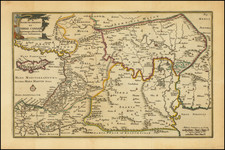
A detailed map of Iraq, produced shortly after the country's independence in 1932. The map shows routes, runways, and military installments, and was likely used in part for military purposes. Three insets detail bridges and routes in specific areas and the fourth shows communication routes with the Mediterranean.
The map is very detailed, with wheel and pack routes, pumping stations, hundreds of bridges and ferries, airstrip lengths, and much more all shown. A list of "Liwa Headquarters" is included, which likely refers to Iraqi military divisions in the country. The style of the map appears more military than civilian, with long straight roads and curt language. The English text and use of the term Liwa suggest that the map is British.
This map dates to the early days of an independent Iraqi kingdom, which lasted from 1932 to 1947. The period from 1933 to 1939 was somewhat troubled, with the real power lying in the military. The British presence in the area continued through the kingdom era after independence, and an Anglo-Iraqi War was fought in 1941 after an Axis-friendly coup d'etat occurred. As such, it would still have made sense for the British government to produce maps such as this one, where the layout and defense capabilities of the country are readily apparent.
The Qatar National Library holds this same map, although their copy appears on two sheets. This institution dates the work to 1936.

![[Arabian Peninsula] Sexta Asie Tabula [Arabia Felix.]](https://storage.googleapis.com/raremaps/img/small/84313.jpg)