|
||

|

|
|

|
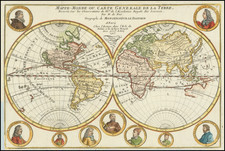
World Map with Explanation of Longitudinal Time Variation
Fascinating map of the world on the Mercator Projection, published in Paris, and which includes a relatively early illustration of time changes around the world.
Much of the world appears familiar to the modern eye. However, a few details stand out as aberrant as compared to current geography. Perhaps the largest of these is the absence of Antarctica; the layout and size of the southern continent would not be verified for over a century after this map was made.
Also of size is the northern thrust of North America, which is attached to Greenland. The extent of far northern lands was unknown in the late-eighteenth century, although a Northwest Passage, either inland or oceanic, was much sought after. Here, in the far northwest, the findings of the Russians on the two Bering expeditions (1725-30, 1733-43) are noted. A river seemingly connects the Great Lakes region to the Pacific via a River of the West. The idea of a River or Sea of the West stems from the work of the renowned geographer Guillaume Delisle, although Delisle never included the feature on his own published maps.
Australia is configured interestingly, especially as this map was made immediately before the first of James Cook's voyages; they would quickly re-define the Australian and New Zealand coastlines. Here Australia is joined to New Guinea and the east coast is conjectural. In the northeast is Terre du St. Esprit, a mixing of the voyages of Pedro Ferdinand de Quiros in the final decade of the sixteenth century and the first decade of the seventeenth with myths of a southern continent and limited reports of Dutch encounters with New Holland. This connected depiction was popular in maps of the mid-eighteenth century as it suggested a very large Terra Australis.
The west coast of Australia is labeled according to the aforementioned Dutch encounters. Carpentarie stems from a voyage in 1623 by Jan Cartensz. He names the land found there after Pieter de Carpentier, the VOC governor of the East Indies at that time. Farther west is Terre de With, which recalls Gerrit Frederikszoon de Witt, captain of the Vianen, which sailed in 1628. Terre d’Endract references the Endracht, the second recorded European ship to contact Australia (1616). In the southwest is Terre de Lewin, named for the Leeuwin, whose crew charted some of the southwest coastline in 1622. Terre de Nuits is named for Pieter Nuyts, a Dutch navigator who commanded the Gulden Zeepaert along the southern coast in 1627.
Beyond the geography of the map, the border is full of additional information that sets this item apart from other contemporary world maps. At the top of the map, a note explains that the Roman numerals indicate the time difference in hours between various parts of the earth when it is noon in Paris. At the bottom, the map shows the time division according to the daily course of the Sun.
To the right side is a table showing the varying lengths of days and nights as one approaches the poles. To the left, the world is split into climactic zones by latitude. These zones are then listed by their distance from the equator in leagues.
The understanding of time change over east-west distance was integral to one method of calculating longitude. If one could calculate one’s difference in time from one’s point of origin, as compared to one’s actual location, then it would be possible to pinpoint one’s longitude. However, designing a timepiece that would tell time accurately at sea proved a formidable task. Over the course of several decades, John Harrison designed one such time piece; after successful sea trials, he was awarded a prize by the Board of Longitude of Britain for his work in inventing the chronometer. The other method for calculating longitude, developed at roughly the same time, is the lunar distance method.
While the map appears to show time zones, these would not be established until the late-nineteenth century. Prior to this, time was a local phenomenon, calculated by each locale based on the sun’s zenith. However, with the advent of rail travel, times needed to be compatible to within a few minutes over a long distance. In 1878, Sir Sandford Fleming, a Canadian, suggested the time zone system of twenty-four zones of one hour each that we use today.
In the lower left is also a fine cartouche, decorated with the instruments of a geographer—globe, quadrant, map, compass, dividers, armillary sphere, books, and more.
Pretot was a French schoolmaster and geographer active in the second half of the eighteenth century. A student of history, Pretot was a member of both the Academies Royales des Sciences et Belles-Artes de Rouen and d'Angers.

![P. Mc.D. Collins' Proposed Overland Telegraph Via Behring's Strait and Asiatic Russia to Europe, Under Russian & British Grants. . . 1864 [accompanied by separate text:] Communication of Hon. William H. Seward, Secretary of State, upon the subject of an Intercontinental Telegraph connecting the Eastern and Western Hemispheres by way of Behring's Strait, In Reply to Hon Z. Chandler, Chairman of The Committee on Commerce of the U.S. Senate, To Which Was Referred The Memorial of Perry McDonough Collins.](https://storage.googleapis.com/raremaps/img/small/87461.jpg)
![(Second World War - Japan) 大觀世界大地圖 [Grand World Map.]](https://storage.googleapis.com/raremaps/img/small/79759.jpg)