This item has been sold, but you can enter your email address to be notified if another example becomes available.


|
||

|

|
|

|
Stock# 68007
Description
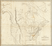
An interesting 18th-century map of the North America, published by J. Wilkes in London in 1796.
Issued shortly before the Louisiana Purchase and the expedition of Lewis & Clark, the map illustrates the lack of knowledge of the American West at the end of the 18th Century.
The west is a massive open area called Quivira, with the no sign of the Rocky Mountains. The River of the West and Oregan River are shown, but not even San Francisco Bay appears on the map.
Very curious configuration of Alaska and the Polar regions, following the discoveries of Cook, but pre-dating Vancouver.


![Vereinigte Staaten Von Nordamerika [United States of America]](https://storage.googleapis.com/raremaps/img/small/79951.jpg)