


|
||

|

|
|

|
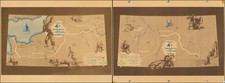
Two fascinating maps commemorating the 4th Infantry Division's campaign spanning from the landings at Normandy to accepting German surrender in Bavaria. The maps include skilled depictions of the war and its effects on soldiers, with several designs showing the many issues faced by this Division.
The map traces the history of the 4th Infantry Division's path through Europe, highlighting points of particular importance. The division was one of the first to land on Utah Beach and was instrumental in securing the beachhead and pushing inland. Despite these initial successes, the inexperienced division was relieved in the task of cutting off the Cherbourg peninsula on June 8th due to poor performance. They would enter Cherbourg on the 25th, before proceeding southwards, encountering resistance until reaching the Varenne river. The division would be the first American troops in Paris (accompanied by Hemingway) on the 25th of August, as noted on the map.
The 4th Infantry Division encountered resistance all the way to the Siegfried Line in at the border with Germany. The first of the two maps culminates with the double-breakthrough of the Siegfried Line just north of Luxembourg, before moving on to the Hurtgen Forest near Aachen. The goal was to render obsolete the full Siegfried Line, also known as the Westwall, a deep line of German defenses spanning from the Dutch coast to Switzerland. This area was reinforced with many anti-tank and anti-personnel structures, making it the last stronghold of German western defense. Allied tacticians decided that the general offensive was particularly vulnerable to a German-controlled dam on the Ruhr, and sent troops to control the dam. They were stopped in the Hurtgen Forest, which saw three months of extremely difficult fighting in which the German troops successfully managed to stop allied advances, using the dense covering of the forest to their advantage. The 4th Division was instrumental in this portion of the war.
The second map commences with the end of the Battle of Hurtgen Forest on the 16th of December, immediately giving way to the Battle of the Bulge, then-unnamed and known as the Ardennes campaign. The 4th Division would hold their positions at Dickweiler and Osweiler, before successfully counterattacking. They would cross the Prum River, and reach Adenau, where they "completed 199 consecutive days of combat." The division would then march circuitously to Worms, crossing the Rhine and fighting their way into Bavaria. They would reach within 16 miles of the Austrian border in May before being relieved and placed on occupation duty, apparently in northern Bavaria on this map.
These maps are well decorated with representations of the 4th Division's time in Europe. Most of the larger drawings show aspects of the war, including pillboxes, soldiers resting, and fallen troops. In Bavaria, a city surrenders. Smaller illustrations reflect the countryside and cities seen by the troops. French cities are depicted with their cathedrals, and some agricultural products and topography are shown along the route. Two soldiers act as compass roses and the Ivy symbol of the 4th division can be seen.
Several names appear on the work. In the legends, the Major General H. W. Blakely and Chief of Staff Richard S. Mare are named. Credit for the map is given to James G. Stewart and another member of the G-2 Section, and the map was reproduced by the 672 Engineer Topographic Corps.
![(Second World War - Bombing of Japan) Tachiarai AF RESTRICTED [Three Reconnaissance Photos of Tachiarai Air Force Base]](https://storage.googleapis.com/raremaps/img/small/90451.jpg)
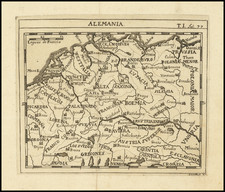
![[Course of the Rhine River] Nova Tractus Totius Rheni Oder Neue beschreibung des Rhein-Strom](https://storage.googleapis.com/raremaps/img/small/58670.jpg)
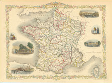
![[France] Europae Tabula III](https://storage.googleapis.com/raremaps/img/small/60010.jpg)