|
||

|

|
|

|
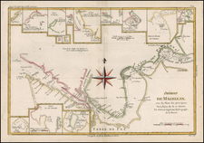
Scarce regional map, which was included in the Dutch edition of the Account of Dampier's Voyages.
In the 1670s, Dampier crewed with buccaneers on the Spanish Main of Central America, which eventually led to his first circumnavigation. On the ship Cygnet, following Pacific-spanning raids that included the East Indies, Manila, and the Spice Islands, Dampier's ship was beached on the northwest coast of Australia in 1688. Waiting for repairs, his scientific interest surfaced as he made notes and drawings on the local fauna and flora. Following three years of further adventures he returned to England. In 1697 he published his experiences in A New Voyage. Described as one of the greatest tales of adventure and exploration ever written, the book was published in several languages. It is reported that Captain Cook used Dampier's nautical observations on his voyages, and Charles Darwin found his books so useful that he took them aboard the Beagle.
This is from de Hondt's rare Dutch edition (Nieuwe Reystogt Rondom de Werrel) of William Dampier’s voyages. The English edition's map, titled "A Map of the Middle Part of America," is identical in its depiction; this edition is re-engraved to use Dutch names. Filled with coastal towns and place names, the map is centered on Honduras, extends north to Maryland and south to include the Amazon River. In the west the Baja Peninsula is labeled California. Sailing routes are indicated throughout, but not identified.
At upper right the inset "De Eylanden van Capo Verde" details the island chain and includes a compass rose and sailing routes.
A rarely seen issue.
![ПОЛИТИЧЕСКАЯ КАРТА ЮЖНОЙ АМЕРИКИ. [Political Map of South America]](https://storage.googleapis.com/raremaps/img/small/90259.jpg)
![[ Florida Indians - Destroying the Enemy's Towns By Night ] Hostium oppida noctu incendendi ratio. XXXI.er absagen](https://storage.googleapis.com/raremaps/img/small/97385.jpg)