


|
||

|

|
|

|
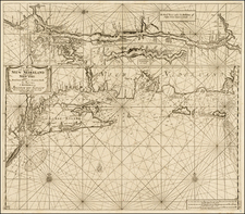
Influential early English chart of the northeastern and mid-Atlantic coast of North America.
For over a century, this sea chart was for the British public the most readily-available general chart of American waters.
The chart covers the coast from Cape Henry in Virginia to Newfoundland and the Gulf of St. Lawrence. There is considerable hydrographic data, though unevenly distributed and particularly concentrated in the economically-important fishing banks off the Canadian Maritimes. Dozens of coastal towns and settlements are named, though apart from the St. Lawrence and a mythical river linking it to the Bay of Fundy there is little interior detail. The odd name "New Scotland" given to modern day New Brunswick is an artifact of earlier efforts to settle the region by Scottish Lord William Alexander early in the 17th century.
The toponymy conveys the impression of English hegemony over most of North America, with only the area north and west of the St. Lawrence controlled by native populations and New France. In fact, at the time the chart was first produced the English presence was largely confined to a strip within perhaps 100 miles of the coast. Much of northern New England and the Maritimes was the scene of ongoing, brutal conflict between the English and the French and their native allies.
According to Baynton Williams, the chart originally appeared in the 1702 and 1721 editions of Atlas Maritimus Novus, bearing the imprint of "Rich.d Mount & Tho: Page." In 1732, the chart appeared for the first time in The English Pilot. The Fourth Book," with the imprint revised to "Will:m Mount & Tho: Page." An entirely new plate was engraved for the 1748 (or according to some sources 1749) edition of the Fourth Book and can be readily discerned by addition of drapery around the title. This new edition was used for at least another forty years, by which time it was terribly out of date, having been superseded by the charts of The Atlantic Neptune.
![A New and Exact Map of the Dominions of the King of Great Britain on ye Continent of North America . . . [Beaver map]](https://storage.googleapis.com/raremaps/img/small/101277.jpg)
