|
||

|

|
|

|
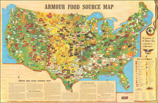
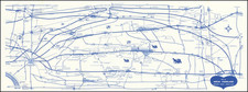
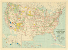
This is an attractive pictorial map of the United States published by the Ford Motor Company as an advertisement for air routes that were supplied in part by their Ford Trimotor aircraft. The map is fascinating, showing domestic and international air routes at the end of the Roaring 20s. The imagery on the map includes planes, wild west themes, mountains, shipping, mythical creatures, and much more.
Several different types of routes are labeled on this map, including mail routes, express passengers (with and without mail), and connecting Pullman sleeper carriages. Routes supplied by Ford Trimotor planes are shown with Ford emblems, including Santa Fe to Los Angeles, Los Angeles to San Francisco via Fresno, Chicago to St. Paul, Dayton to St. Louis, and several other routes. The first Pan Am route, between Key West and Havana, can be seen to fly a Ford Trimotor. The map itself is a fascinating work, showing the extent to which flight had taken over US transport and mail only a decade after the first scheduled passenger flight and two years after Lindbergh's famous transatlantic journey.
The Ford Motor Company played a short-lived role in the early history of civil aviation. Ford acquired the Stout Metal Airplane Company in 1925 and immediately started upgrading their designs from single-engine to trimotor. Between 1926 and 1933, 199 Ford Trimotors were built, and the design was a significant advancement over other commercially available aircraft. Further, the large scale production and Ford assembly line efficiency allowed for low and affordable costs. While Ford managed to dominate the American market for a short period of time, the company exited the market after the rise of modern Boeing and Douglas aircraft. The Ford airplane design never made it to Europe, as it had been effectively copied from Junkers' Fokker aircraft and violated intellectual property rights.
This map appeared in a September 1928 issue of The Saturday Evening Post and the August 1928 issue of The Literary Digest. This is a very scarce separately published example. The map appears to be adapted from a federal aviation map of the same title which was published in five editions between 1928 and 1935.