|
||

|

|
|

|
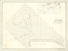
Rare 19th century Duluth, Minnesota, cadastral map, focusing on a burgeoning industrial and worker housing area in West Duluth.
The factories of the Duluth Iron & Steel Co., Minnesota Car Co's Works (crossed out to read: "West Duluth Car Co.'s Works."), and factories making furniture, sash, doors, and blinds are shown. The proximity to the York Steel Plant is noted in manuscript.
The late 1880s and 1890s were a tumultuous time in the industrial history of Duluth, with numerous strikes and worker riots.
This example contains extensive contemporary manuscript annotations, including the coloring in red of plots that were built up or purchased; the naming of local factories; and the inclusion of a "proposed railway" bridge. The map was "From Geo E. Mansfield, Spalding Hotel, Duluth. Minn. April 15, 96."
Rarity
The map was prepared by job photo-lithographer Robert A. Welcke Photo-Lith in New York and was distributed exclusively in Duluth by J.C. & R.M. Hunter and the Duluth Union National Bank Bl'dg.
This mode of production probably accounts for the map's rarity today: neither OCLC nor RBH record any examples, and this is the only one we could find in general online searches.
![Diagram showing ceded and reserved Chippewa lands in Minnesota [with:] In the Supreme Court of the United States. October Term, 1912.](https://storage.googleapis.com/raremaps/img/small/93674.jpg)

![[ Mille Lacs Lake, Minnesota ] Thomas W. Allison Milaca, Minn. Reference: The Security State Bank Princeton, Minn.](https://storage.googleapis.com/raremaps/img/small/101935.jpg)
![[ St. Paul, Minnesota - Harley Davidson ] Route of the Winter Carnival Grande Parade -- Saturday January 27th. 1940 . . . .](https://storage.googleapis.com/raremaps/img/small/102073.jpg)