|
||

|

|
|

|
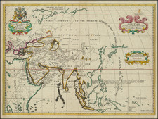
Striking Eighteenth-Century Map of Asia
Fine example of Tobias Conrad Lotter's large format map of Asia, based on the cartography of the pre-eminent French cartographer of the eighteenth-century, Guillaume de L’Isle.
The map embraces the whole of Asia, from the Arabian Peninsula to the East Indies and the tip of New Guinea and Australia. The north of Europe and Tartary are recognizably delineated but farther east has unfinished coastlines for Nova Zembla. To the northeast is no coastline; Eastern Siberia is an enigma.
The interior is remarkably detailed, with political divisions shown with dotted lines, cities large and small are marked, as are rivers and mountains. In the upper left corner is a decorative cartouche; the ornate frame gives way to mountains and a grand parade of elegant, turbaned men on camels. Below this are a series of scales in their own frame, and in the lower left corner is a note explaining the ongoing geographical work on the part of the author.
Japan is separated from the mainland by a narrow strait. Instead of Hokkaido, there is a peninsula identified as Terra Yeco. Korea is a peninsula to the west. In the Pacific are the fictional Terre de la Compagnie and I. Staats.
There remains plenty of space for a Northwest or a Northeast Passage, the most-hoped for geographic chimera of the early modern period. Indeed, there is a Portus glacial near Nova Zembla—an icy doorway, perhaps around Asia and into the Pacific.
North Pacific chimeras: Yesso, De Gama, and Compagnie Land
The etymology of the idiom Yesso (Eso, Yeco, Jesso, Yedso) is most likely the Japanese Ezo-chi; a term used for the lands north of the island of Honshu. During the Edō period (1600-1886), it came to represent the ‘foreigners’ on the Kuril and Sakhalin islands. As European traders came into contact with the Japanese in the seventeenth century, the term was transferred onto European maps, where it was often associated with the island of Hokkaido. It varies on maps from a small island to a near-continent sized mass that stretches from Asia to Alaska.
The toponym held interest for Europeans because the island was supposedly tied to mythic riches. Father Francis Xavier (1506-1552), an early Jesuit missionary to Japan and China, related stories that immense silver mines were to be found on a secluded Japanese island; these stories were echoed in Spanish reports. The rumors became so tenacious and tantalizing that Abraham Ortelius included an island of silver north of Japan on his 1589 map of the Pacific.
Yesso is often tied to two other mythical North Pacific lands, Gamaland and Compagnies Land. Juan de Gama, the grandson of Vasco de Gama, was a Portuguese navigator who was accused of illegal trading with the Spanish in the East Indies. Gama fled and sailed from Macau to Japan in the later sixteenth century. He then struck out east, across the Pacific, and supposedly saw lands in the North Pacific. These lands were initially shown as small islands on Portuguese charts, but ballooned into a continent-sized landmass in later representations.
Several voyagers sought out these chimerical islands, including the Dutchmen Matthijs Hendrickszoon Quast in 1639 and Maarten Gerritszoon Vries in 1643. Compagnies Land, often shown along with Staten Land, were islands sighted by Vries on his 1643 voyage. He named the islands for the Dutch States General (Staten Land) and for the Dutch East India Company (VOC) (Compagnies, or Company’s Land). In reality, he had re-discovered two of the Kuril Islands. However, other mapmakers latched onto Compagnies Land in particular, enlarging and merging it with Yesso and/or Gamaland.
In the mid-eighteenth century, Vitus Bering, a Danish explorer in Russian employ, and later James Cook would both check the area and find nothing. La Perouse also sought the huge islands, but found only the Kurils, putting to rest the myth of the continent-sized dream lands.
Tobias Conrad Lotter (1717-1777) is one of the best-known German mapmakers of the eighteenth century. He engraved many of the maps published by Matthaus Seutter, to whose daughter Lotter was married. He took over Seutter’s business in 1756. Lotter’s son, M. A. Lotter, succeeded his father in the business.

![Asia Cum Omnibus Imperiis Provinciis Statibus et Insulis Iuxta Observationes Recentissimas et Accuratissimas… [Asia, with all the empires, provinces, states, and islands, according to the most recent and accurate observations...]](https://storage.googleapis.com/raremaps/img/small/95548.jpg)