|
||

|

|
|

|
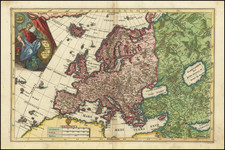
This is a map showing Europe representing the continent as a matronly housewife. This depiction follows a centuries-old tradition in which Europa, the mythical Phoenician queen, is overlain on a map of Europe. In this present representation, Europa's head constitutes the Iberian peninsula, her scarf France, the British Isles, and the Low Countries, and her robe Eastern Europe. This work is from Geheimzinnige Toebereidselen tot eene Boertige Reis Door Europa, Part I.
The map underlaying the depiction is detailed, with cities, rivers, borders, and the names of regions all shown. The depiction of Europa is attractively constructed.
Organizing maps after human forms dates from at least the Middle Ages and continues to this day. Europa Regina, the most common name given to maps showing Europa, was introduced during the reigns of Fernidand II and Charles V and used primarily to show Habsburg dominions. Thus, it made sense Europa's head and crown to be in Spain and her heart in the Holy Roman Empire. Over time, the depiction was also used to show the extent of Christendom, European dominance over the world, and mythological representations of Europe, though it became less ubiquitous after the mid-17th century. The present map is different from these earlier versions for two reasons, the first being that Europa is overlain on a map, and not herself the map, and the second being that Europa is a lower-class woman, and not a queen or princess.
Several sources suggest that this an anti-Napoleonic image. This is doubtful for several reasons, including historical, publishing, and artistic context. The first appearance of Boertige Reis Door Europa in 1794 makes a direct connection to Napoleon unlikely. While Napoleon was already a semi-popular figure in France, he had not yet assumed command of the armies of Italy. It is doubtful other parts of the continent would have been preoccupied with him at the time, although they may have been concerned by the French Revolution. Further, no evidence for this supposed political commentary appears on the map. There are no overt references to revolutionary France and no obvious difference between countries supporting and opposing the revolution. Finally, the work itself is a satirical account of a Dutch farmer's travels through Europe, likely heavily influenced by the earlier Candide. This map appeared at the front of the first volume, alongside another full map of Europe. For a work that does not primarily focus on the revolution, it seems more like this is simply a tongue-in-cheek representation of Europe, without any major political implications.
![(Prussian Octopus) En 1788 Mirabeau disait deja: La Guerre est l’industrie Nationale de la Prusse [Already in 1788 Mirabeau was saying: War is the national industry of Prussia]](https://storage.googleapis.com/raremaps/img/small/76554.jpg)