|
||

|

|
|

|
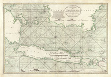
The First Accurate Sea Chart of the Region. Produced by Hessel Gerritsz Shortly Before His Death in 1632.
Very rare engraved sea chart of Southeast Asia by Hessel Gerritsz, first engraved between 1628 and 1632, and published exclusively by Willem and Johannes Blaeu in the very rare German-language first edition of the Atlas Novus in 1634.
As Chief Cartographer of the VOC, Gerritsz had designed the chart for use by Indiaman navigators at sea, and the map represents the state of the art in geographical knowledge available to the Dutch East India Company at the time.
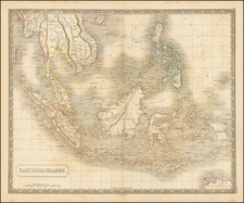
The map stretches as far north as Korea ("Corea insula.") and the southern half of Japan. To the west, the map covers all of India and its rich trading ports. In the east, the map covers the then-known extent of Papua New Guinea and islands of the western South Pacific. In the south, the map shows the northwest coast of Australia, namely "G.F. de Wits landt" and the "Willems Revier".
The Philippines is very well rendered. The configuration, which is roughly shared with Jansson's 1630 map of Southeast Asia, is far better than the other maps of the islands from the first half of the 17th century. The Gerritsz map improves upon the Jansson in its placement of Manila vis-a-vis the Bay of Manila.
It is not known if Gerritsz ever had the map printed and upon his death in 1632 the disposition of this plate and five others of similarly sensitive areas was in the hands of his executors and potentially his former employer, the VOC. As Gerritsz's death had left the position of Chief Cartographer of the VOC vacant, Willem Blaeu seized the opportunity for a role that would have been totally unobtainable to him just a decade earlier. With the assistance of his friend Laurens Reael, Blaeu not only acquired Gerritsz's former position, he also acquired this copperplate for his commercial operation.
Blaeu and Gerritsz had been previously acquainted when the latter began his career at the Blaeu firm studio in Alkmaar. Gerritsz was ten years younger the Willem Blaeu, and when the shop moved to Amsterdam, the younger man followed it.
Laurens Reael (1583-1637) looms large in the history of the East Indies and Dutch mapping during the first decades of the 17th century. His career took off when he made his way to the East Indies in a convoy of four ships in 1611. Upon arrival at Ternate in the Moluccas, he quickly rose to become the third Governor-General of the Dutch East Indies. During his first year as Governor-General, he saw the arrival of both the Joris von Spilbergen and the Schouten-Le Maire voyages. He held the post until 1619, when he was replaced by Jan Pietereszoon Coen who had fewer qualms about using force to achieve the goals of the VOC. Reael became a member of the Amsterdam Chamber of the VOC in 1625, a post he held until his death 12 years later. He held a variety of very high ranking military and diplomatic posts throughout this time as well.
Blaeu rewarded Reael for his assistance by dedicating the present map (in its final state) to him with a long list of the latter's titles:
Nobmo. Fortmoq Viro et Heroi
D. LAURENTIO REAL
Equiti, Inidae Orient. ol. Gubernatori Supremo, nup. Thalassiarchae classis Britannici Vicario, et nomine ORd Belgicae Foed. ad Regem Daniae Legato, Urbis Amsterdamens. Senatori et Scabino, nec non Concilii Societatis Indicae Orientalis Assessori, vario literarum ac doctrine genere claro, Tabulam hanc. D.D. Guilielmus Blaeu.
Rarity and States
Current scholarship suggests that this map appeared only in 1634 German-language first edition of the Atlas Novus, which Willem and Johannes Blaeu had quickly (and somewhat sloppily) pushed to market. The atlas was not published in large numbers before it was substantially reworked in the following years. Koeman, in the appendix to the sixth volume of Atlantes Neerlandici (1983) could mention only one example, without any locating information. Schilder, in Volume IV of Monumenta Cartographica Neerlandici (page 24) relates that three examples had been located. We are aware of the separate map appearing only once at auction (Reiss & Sohn in 2004) and once with a dealer in the Netherlands.
- First state: Lacking the decorative cartouches at the center-top and lower-left, as well as the putti and scale in the lower-right corner.
- Second state: With the title amended, the cartouches and scale added, but lacking text in the dedicatory cartouche at lower-left.
- Third and final state: With text added to the dedicatory cartouche, and substantial changes in the interior of the landmasses, including the addition of mountains. This is by far the most common of the states.
Willem Janszoon Blaeu (1571-1638) was a prominent Dutch geographer and publisher. Born the son of a herring merchant, Blaeu chose not fish but mathematics and astronomy for his focus. He studied with the famous Danish astronomer Tycho Brahe, with whom he honed his instrument and globe making skills. Blaeu set up shop in Amsterdam, where he sold instruments and globes, published maps, and edited the works of intellectuals like Descartes and Hugo Grotius. In 1635, he released his atlas, Theatrum Orbis Terrarum, sive, Atlas novus.
Willem died in 1638. He had two sons, Cornelis (1610-1648) and Joan (1596-1673). Joan trained as a lawyer, but joined his father’s business rather than practice. After his father’s death, the brothers took over their father’s shop and Joan took on his work as hydrographer to the Dutch East India Company. Later in life, Joan would modify and greatly expand his father’s Atlas novus, eventually releasing his masterpiece, the Atlas maior, between 1662 and 1672.
Hessel Gerritsz (1581-1632) was a noted Dutch mapmaker, engraver, and publisher who was also the official hydrographer of the Dutch East India Company. Gerritsz was born in Assum. His first exposure to mapmaking was as an apprentice to Willem Janszoon Blaeu, beginning in 1607. In 1610, Gerritsz began his own publishing business.
Gerritsz’s reputation grew quickly. In 1617, upon the recommendation of Petrus Plancius, Gerritsz was named as the cartographer to the Dutch East India Company (VOC). This meant that Gerritsz had access to the geographical information gathered by VOC navigators, but he could also still sell his own maps to the public. He reviewed the journals of the VOC, then prepared and corrected charts for their ships. In this post, Gerritsz created the first maps to include many new geographic features in the Indian and Pacific Oceans; these included some of the first European encounters with the coast of Australia.

![[ Lhasa, Tibet ] Bietala](https://storage.googleapis.com/raremaps/img/small/97334.jpg)
![[ Old Color! ] Nova Tabula Insularum Iavae, Sumatrae, Borneonis et Aliarum Mallaccam usquae delineata in insula Iava . . .](https://storage.googleapis.com/raremaps/img/small/78233.jpg)