|
||

|

|
|

|
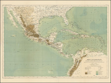
One of the Largest 19th Century Printed Maps of Mexico
Remarkable large format map of Mexico, published by Rand McNally & Co. in Chicago.
The map provides a meticulous accounting of the telegraph lines, railroads, and steamship lines (existing and proposed) with connecting routes to the United States also shown. A symbol locating "Ports of entry for foreign trade" and points of entry for coasting trade are noted.
This map was published at the end of the González Interregnum, the period between 1880 and 1884 when General Manuel González held the presidency after Porfirio Díaz had stepped down. The period was marked by increasing openness to investment by U.S. nationals and an attempt by the Mexican government to make the country seem like a safe and attractive place to invest. This map clearly means to advance that cause by displaying Mexico's advanced national communications network.
Rumsey notes:
This does not look like the "normal" Rand McNally map - it is probably a separately made map that they acquired the rights to. This copy [and our copy] was sold in England by Edward Stanford and has his label on the case. Map is in four sheets, each dissected into 21 sections. With outline color by state, topography shown in brown, and railways and shipping routes in red. . . .
Rarity
This 1884 state of the map is apparently unrecorded. OCLC locates several examples of the 1882 edition.
Prior to this example appearing in 2020, we were unable to locate any examples of this map on the market.
Rand McNally & Co. is a large American map and navigation company best known for its annual atlases. The company got its start in 1856, when William Rand opened a print shop in Chicago. He was joined in 1858 by a new employee, Andrew McNally. Together, the men established their namesake company in 1868. Originally, the company was intended to print the tickets and timetables for the trains running to and through Chicago; their first railway guide was published in 1869.
By 1870, they had shifted from just printing to publishing directories, travel guides, and newspapers. Their first map appeared in 1872 in a railway guide. The map was produced using a new wax engraving method, a cheaper process that gave the company an edge.
By 1880 Rand McNally had entered the education market with globes, wall maps, and geography texts for students. In 1923, Rand McNally published the first Goode’s World Atlas, named after its editor, Dr. J. Paul Goode. For generations afterward, this would be the standard classroom atlas.
In 1899, William Rand left the company, but McNally and his family remained, controlling the company for over a century. In 1904, they published their first road map intended for automobiles and by 1907 were publishing Photo-Auto Guides, which combined photography and mapping to help drivers. In 1924, they produced the Auto Chum, a precursor to their famous road atlases. Rand McNally would remain the leader in road maps and atlases throughout the twentieth century.
In 1937, Rand McNally opened its first store in New York City. Ever on the frontier of technology, Rand McNally pioneered the scribing process for printing tickets in 1958 and printed their first full-color road atlas in 1960. Arthur Robinson developed his now-famous projection of Rand McNally in 1969. By the 1980s, the company was exploring digital reproduction and digital databases of maps for truckers. In the 1990s, they lead the charge to develop trip-planning software and websites. Today, most of its products are available online or in a digital format, including maps for tablets and phones.
![[Restricted] New Orleans (0-6)](https://storage.googleapis.com/raremaps/img/small/68648.jpg)
![[Texas and Western Louisiana]](https://storage.googleapis.com/raremaps/img/small/66617.jpg)