|
||

|

|
|

|
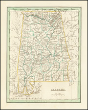
Detailed map published by the United States Government to illustrating public lands in Northern Alabama.
The focal point of the map are the lands ceded by the Cherokee in December 1835. The map also locates the US General Land Offices in Huntsville and Mardisville (now a small town in Talladega County) and recently created Land Districts.
Treaty of New Echota
The Treaty of New Echota was signed on December 29, 1835, in New Echota, Georgia, by officials of the United States government and representatives of a minority Cherokee political faction, the Treaty Party.
The treaty established terms under which the entire Cherokee Nation ceded its territory in the southeast and agreed to move west to the Indian Territory. Although the treaty was not approved by the Cherokee National Council nor signed by Principal Chief John Ross, it was amended and ratified in March 1836, and became the legal basis for the forcible removal known as the Trail of Tears.
In 2019, Cherokee Nation principal chief Chuck Hoskin Jr. cited a provision of the treaty that states that the Cherokee "shall be entitled to a delegate in the House of Representatives of the United States whenever Congress shall make provision for the same," in announcing that he intended to appoint, for the first time, a Congressional delegate from the Cherokee Nation. Pending a decision of the Cherokee National Council, Hoskin said he would nominate Kimberly Teehee, a member of the Cherokee Nation who formerly served as a policy advisor in the administration of President Barack Obama, to the post.