


|
||

|

|
|

|
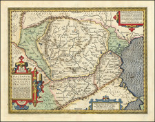
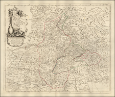
A detailed map of Transylvania, based upon Blaeu's earlier work on the area. The region is shown in detail, with major cities, towns, rivers, forests, topography, and more all shown. Detail extends into neighboring regions, including Hungary, Walachia, Russia (Ukraine), and "Transalpina" (southern Romania). The map includes a decorative cartouche.
Two names are given for the region, Transylvania, from the Latin roots meaning across the forest, and "Sibenburgen" meaning "the seven castles" in German. This latter name refers to the seven ethnically German cities in the region. Exactly which settlements this refers to has been lost to history, though not all of the most notable Transylvanian Saxon cities of the region are shown on the map. This omission is intriguing for a map that explicitly refers to the "Sibenburgen."
At the time this map was created, Transylvania was under the rule of the Habsburgs. The region was relatively opposed to imperial oppression, and several temporarily successful revolutions occurred. The region managed to retain relative independence until 1657, when Gerge II Rakoczi's attempt to win the Polish throne led him to ally with the Swedes during the so-called "Deluge." The resulting conflict led to the invasion of Transylvania by the Ottoman Empire, and its new status as a client state.
Two different editions of this map attributed to Merian appear. This might be the earlier version of the map, with less detail and more obviously based on Blaeu's map. The added detail in the other version comes at the cost of visual simplicity, which the present example preserves.
Mathaus Merian (1593-1650) was the father of engraver Matthäus the Younger, and of the painter, engraver, and naturalist Maria Sibylla Merian. He was born in Basel, Switzerland and trained in engraving in Zurich. After a time in Nancy, Paris and Strasbourg, he settled in Frankfurt. While there, he worked for Johann Theodor de Bry, the publisher and son of the travel writer. In 1617, he married Maria Magdalena de Bry, Johann Theodor’s daughter. In 1623, Merian took over the de Bry publishing house upon the death of his father-in-law. Merian’s best known works are detailed town views which, due to their accuracy and artistry, form a valuable record of European urban life in the first half of the sixteenth century
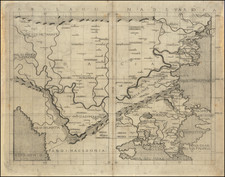
![[Poland, Croatia, Slovenia, Hungary, Serbia, Romania, Ukraine, Bulgaria] (La discrittione della Transylvania et parte del l'Ungaria, et il simil della Romania)](https://storage.googleapis.com/raremaps/img/small/59225.jpg)