|
||

|

|
|

|
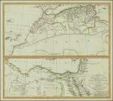
Two engraved maps on one sheet showing the Mediterranean, with a focus on North Africa. The upper map extends from the Atlantic to "Tripoly," while the lower map extends from Tunisia to the Holy Land. In addition to the many states of North Africa, Sicily, Cyprus, Crete ["Candia"], Malta, Madeira, the Canary Islands, and the Balearic Islands are all shown. Each map includes a decorative compass rose and a cartouche.
Annotations and detail in North Africa are extensive. The Nile is shown to just north of Luxor, and the many deserts and towns of Egypt are named. To the west, political subdivisions become more questionable. The Kindm. of Faisan "containing 101 Towns, [producing] the best Dates and Sena in abundance" appears, but historical references on this supposed entity are slim. Other towns, fortresses, and "fountains" are described, though this also appears to be more legendary than geographical. Nomadic tents dot southern Algiers and Tafilete. These many facets of the map make for a fascinating and attractive depiction of North Africa and the Mediterranean.
Emanuel Bowen (1694?-1767) was a British engraver and print seller. He was most well-known for his atlases and county maps. Although he died in poverty, he was widely acknowledged for his expertise and was appointed as mapmaker to both George II of England and Louis XV of France. His business was carried on by his son, Thomas Bowen. He also trained many apprentices, two of whom became prominent mapmakers, Thomas Kitchin and Thomas Jeffreys.
![Carte de la Turquie, de l'Arabie et de la Perse, dressée sur les mémoires les plus récents rectifiée par les observations de Messieurs de l'Académie Royale des Sciences par G. de L'Isle, géographe. [Map of Turkey, Arabia, and Persia, drawn up based on the most recent memoirs and corrected by the observations of the gentlemen of the Royal Academy of Sciences by G. de L'Isle, geographer.]](https://storage.googleapis.com/raremaps/img/small/94075.jpg)
![Secunda Africa Tabula [North Africa, Malta, Sicily, and Sardinia]](https://storage.googleapis.com/raremaps/img/small/72485.jpg)